
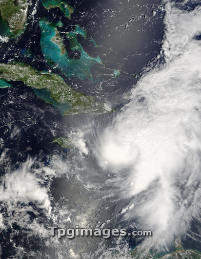
Hurricane Ernesto. Satellite image of hurricane Ernesto over Hispaniola on 27th August 2006. Cuba is at upper left. At this point Ernesto was classified as a category 1 hurricane, with maximum sustained winds of about 120 kilometres per hour. Ernesto bought torrential rain to the island, causing flooding, which killed one person. As it moved over the island it lost strength and was downgraded to a tropical storm. Ernesto was the first hurricane of the 2006 Atlantic hurricane season. Hurricanes are enormous rotating storm systems in which winds can reach over 240 kilometres per hour. They can cause immense damage if they hit built-up areas, but lose energy quickly over land. Image taken by the MODIS instrument on NASA's Terra satellite.
| px | px | dpi | = | cm | x | cm | = | MB |
Details
Creative#:
TOP03206828
Source:
達志影像
Authorization Type:
RM
Release Information:
須由TPG 完整授權
Model Release:
N/A
Property Release:
N/A
Right to Privacy:
No
Same folder images:
 Loading