
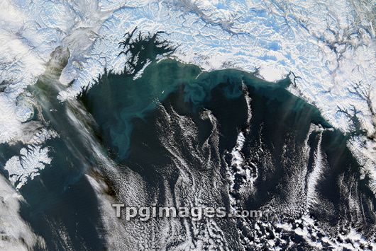
Alaskan coastline, satellite image. North is at top. This is part of the southern coastline of Alaska, with the Gulf of Alaska (across bottom), and ice-covered land across top. Prince William Sound is the bay just left of upper centre. Wisps of clouds (white) are seen over the gulf. The turquoise swirls in the water are sediments ground up and carried down to the sea by glaciers. The area covered by this image is around 600 kilometres across. Image obtained on 7 January 2007, by the MODIS instrument on NASA's Aqua satellite.
| px | px | dpi | = | cm | x | cm | = | MB |
Details
Creative#:
TOP03206979
Source:
達志影像
Authorization Type:
RM
Release Information:
須由TPG 完整授權
Model Release:
N/A
Property Release:
N/A
Right to Privacy:
No
Same folder images:
PRINCEWILLIAMSOUNDGULFOFALASKACOASTLINEICESNOWMOUNTAINRANGESEDIMENTSEAOCEANCLOUDWATERLANDARCTICCOASTPACIFICALASKAUSANORTHAMERICAGLACIOLOGYEARTHOBSERVATIONGEOGRAPHYSATELLITEIMAGEFROMSPACEMODISSATELLITEAQUA7THJANUARY2007WINTER200721STCENTURY2007/1/77-Jan-07ENVIRONMENTNORTHAMERICANUNITEDSTATESAMERICANUSGEOGRAPHICALNATURECLOUDSMOUNTAINSGLACIALSEDIMENTGLACIALCOASTALBAYBAYSFJORDFJORDSGLACIERGLACIERSALASKANMODERATERESOLUTIONIMAGINGSPECTRORADIOMETERENVIRONMENTAL
200720072007/1/721ST7-Jan-077THALASKAALASKAALASKANAMERICAAMERICANAMERICANAQUAARCTICBAYBAYSCENTURYCLOUDCLOUDSCOASTCOASTALCOASTLINEEARTHENVIRONMENTENVIRONMENTALFJORDFJORDSFROMGEOGRAPHICALGEOGRAPHYGLACIALGLACIALGLACIERGLACIERSGLACIOLOGYGULFICEIMAGEIMAGINGJANUARYLANDMODERATEMODISMOUNTAINMOUNTAINSNATURENORTHNORTHOBSERVATIONOCEANOFPACIFICPRINCERANGERESOLUTIONSATELLITESATELLITESEASEDIMENTSEDIMENTSNOWSOUNDSPACESPECTRORADIOMETERSTATESUNITEDUSUSAWATERWILLIAMWINTER
 Loading