
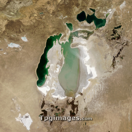
Aral Sea. Satellite image of the Aral Sea (green). Sediment (pale green), vegetation (dark green) and dry salt beds (white) left by evaporating water can be seen. This inland lake is found between Uzbekistan and Kazakhstan and used to be the fourth largest lake in the world. By 2005 it had shrunk to be only the eighth largest and at the time it was predicted that it would disappear by 2020. In August 2005, the Dike Kokaral dam was built to separate the small North Aral Sea (upper right) from the large South Aral Sea (centre) to prevent further shrinking. By 2007 the dam had led to a growth in the North Aral Sea, but not in the South Aral Sea. Image taken on 15th April 2005 by the MODIS camera on NASA's Terra satellite. See E590/250 for the Aral Sea in 2007.
| px | px | dpi | = | cm | x | cm | = | MB |
Details
Creative#:
TOP03208573
Source:
達志影像
Authorization Type:
RM
Release Information:
須由TPG 完整授權
Model Release:
N/A
Property Release:
N/A
Right to Privacy:
No
Same folder images:
 Loading