
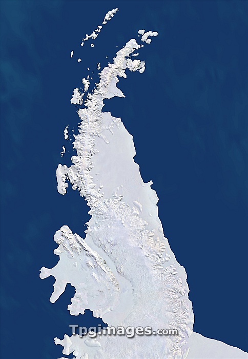
Antarctic Peninsula, satellite image. This mountainous peninsula is flanked by the Larsen Ice Shelf to the east, and the Wilkins and George VI Ice Shelves to the west. The Larsen Ice Shelf suffered catastrophic collapses in 1995 and 2002. Based on satellite data assembled for International Polar Year (2007-2008), this image-map offers a recent snapshot of Antarctica's dynamic coastline. This image uses data from four satellite systems (see C004/566). The datasets used for this image were assembled for the International Polar Year (2007-2008).
| px | px | dpi | = | cm | x | cm | = | MB |
Details
Creative#:
TOP06662665
Source:
達志影像
Authorization Type:
RM
Release Information:
須由TPG 完整授權
Model Release:
NO
Property Release:
NO
Right to Privacy:
No
Same folder images:
antarcticpeninsulalarseniceshelfwilkinsiceshelfgeorgeviiceshelfpeninsulaantarcticasouthernoceangeographyearthobservationsatelliteimagesatellitelandsatavhrrmodisczcsadvancedveryhighresolutionradiometerantarcticchlorophyllconcentrationcloudfreecloud-freecloudlesscoastcoastalcoastalzonecolorscannercoastlinecoastlinescoldfromspacefrozengeographicaliceiceshelficyinternationalpolaryear2007-2008landmoderate-resolutionimagingspectroradiometermountainmountainsnaturalcolournaturepolarregionregionalseashelvessnowsouthernwater"
"2007-2008advancedantarcticantarcticantarcticaavhrrchlorophyllcloudcloud-freecloudlesscoastcoastalcoastalcoastlinecoastlinescoldcolorcolourconcentrationczcsearthfreefromfrozengeographicalgeographygeorgehighiceiceiceiceiceicyimageimaginginternationallandlandsatlarsenmoderate-resolutionmodismountainmountainsnaturalnatureobservationoceanpeninsulapeninsulapolarpolarradiometerregionregionalresolutionsatellitesatellitescannerseashelfshelfshelfshelfshelvessnowsouthernsouthernspacespectroradiometerveryviwaterwilkinsyearzone
 Loading