
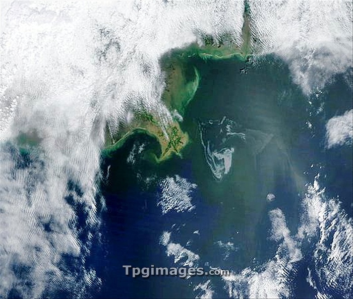
Gulf of Mexico oil spill, 2010. Satellite image of the oil slick (white, centre right) caused by the explosion of the Deepwater Horizon oil platform in the Gulf of Mexico on 20th April. Over five thousand barrels of oil a day leaked into the Gulf of Mexico, 80 kilometres from the coast of Louisiana, USA, harming local wildlife and fishing industries. Image taken by the Moderate Resolution Imaging Spectroradiometer (MODIS) instrument on NASA's Terra satellite on 1st May 2010.
| px | px | dpi | = | cm | x | cm | = | MB |
Details
Creative#:
TOP06665832
Source:
達志影像
Authorization Type:
RM
Release Information:
須由TPG 完整授權
Model Release:
NO
Property Release:
NO
Right to Privacy:
No
Same folder images:
oilspilloilslicknorthamericausagulfofmexicopollutingspillingearthobservationenvironmentalscienceindustrysatelliteimagesatellitemodisterra21stcentury1may2010accidentamericanbpcloudcloudycoastcoastalcoastlinecontaminatedcontaminationdamagedamageddeepwaterhorizondisasterexplosionhumanimpactindustrialmoderateresolutionimagingspectroradiometeroilplatformoilrigpollutedpollutionunitedstatesus"
"1201021staccidentamericaamericanbpcenturycloudcloudycoastcoastalcoastlinecontaminatedcontaminationdamagedamageddeepwaterdisasterearthenvironmentalexplosiongulfhorizonhumanimageimagingimpactindustrialindustrymaymexicomoderatemodisnorthobservationofoiloiloiloilplatformpollutedpollutingpollutionresolutionrigsatellitesatellitescienceslickspectroradiometerspillspillingstatesterraunitedususa
 Loading