
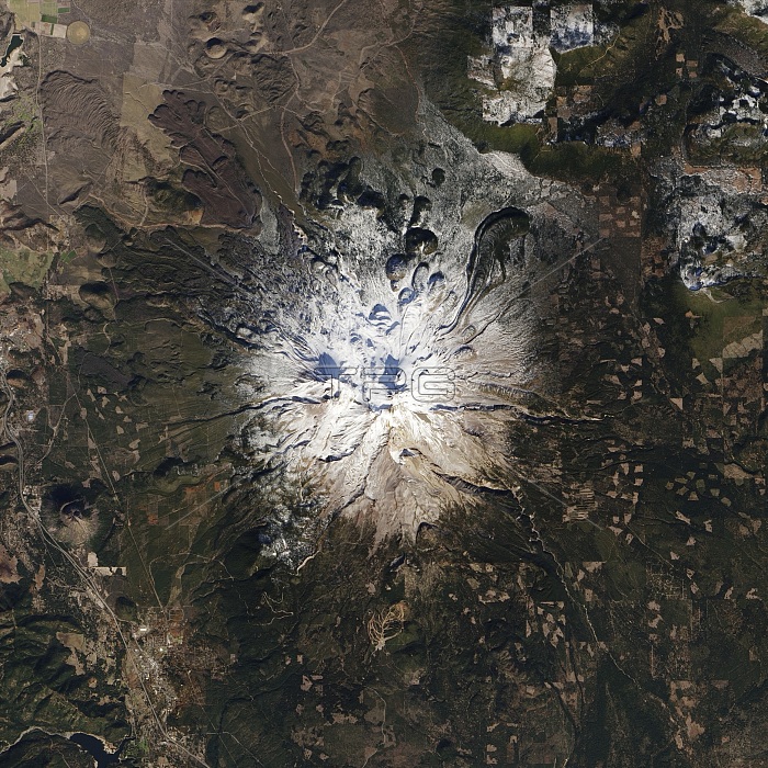
Mount Shasta, USA. Satellite image of Mount Shasta, California, USA, covered in snow. Mount Shasta is a potentially active volcano located at the southern end of the Cascade Range. Although covered in snow here, this was a particularly dry winter for the region and snow cover had significantly decreased by January 2014. This snow deficit mirrored the wider issue of historically low snow and rain totals around California. Imaged by the Operational Land Imager (OLI) onboard NASA's Landsat 8 satellite, on 1st november 2013.
| px | px | dpi | = | cm | x | cm | = | MB |
Details
Creative#:
TOP14563641
Source:
達志影像
Authorization Type:
RM
Release Information:
須由TPG 完整授權
Model Release:
N/A
Property Release:
No
Right to Privacy:
No
Same folder images:
01/11/20131november1st201321stcenturyamericancaliforniacaliforniancascaderangeclimatologicalclimatologycolddeficitdryearthobservationenvironmentenvironmentalsciencefromabovefromspacegeographicalgeographylandsat8meteorologicalmeteorologymountshastano-onenobodynorthamericaolioperationallandimagerpotentiallyactiveprecipitationsatelliteimagesnowsnowcoversnow-coveredsnowyunitedstatesususavolcanicvolcanovolcanologyvulcanologyweatherwinter
01/11/201311st8201321staboveactiveamericaamericancaliforniacaliforniancascadecenturyclimatologicalclimatologycoldcoverdeficitdryearthenvironmentenvironmentalfromfromgeographicalgeographyimageimagerlandlandsatmeteorologicalmeteorologymountno-onenobodynorthnovemberobservationolioperationalpotentiallyprecipitationrangesatellitescienceshastasnowsnowsnow-coveredsnowyspacestatesunitedususavolcanicvolcanovolcanologyvulcanologyweatherwinter
 Loading