
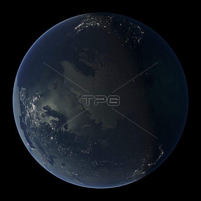
Earth at night. Map showing the Arctic and the urban and industrial lights over the northern hemisphere at night. It was created by combining data from NASA's Moderate Resolution Imaging Spectroradiometer (MODIS) aboard the Terra satellite. Most lights originate from artificial lighting in cities and towns, other light sources originate from biomass burning, such as fires and oil rig flares. This image illustrates modern human impact on the planet.
| px | px | dpi | = | cm | x | cm | = | MB |
Details
Creative#:
TOP14563725
Source:
達志影像
Authorization Type:
RM
Release Information:
須由TPG 完整授權
Model Release:
N/A
Property Release:
No
Right to Privacy:
No
Same folder images:
21stcenturyamericananthropocenearcticartificiallightingartworkasiaasianbiomassburningcanadiancitiescitycityatnightcitylightsearthearthatnightearthobservationeuropeeuropeangasflaresgeographicalgeographyhumanimpacthumanpresenceillustrationlightlightpollutionmankindmoderateresolutionimagingmodernmodernitymodisnightlightsnighttimenight-lightnorthamericanorthpoleoilrigplanetpolarsatellitesatelliteimagespectroradiometerunitedstatesurbanisationurbanizationusaworldatnight
21stamericaamericananthropocenearcticartificialartworkasiaasianatatatbiomassburningcanadiancenturycitiescitycitycityeartheartheartheuropeeuropeanflaresgasgeographicalgeographyhumanhumanillustrationimageimagingimpactlightlightlightinglightslightsmankindmoderatemodernmodernitymodisnightnightnightnightnightnight-lightnorthnorthobservationoilplanetpolarpolepollutionpresenceresolutionrigsatellitesatellitespectroradiometerstatestimeunitedurbanisationurbanizationusaworld
 Loading