
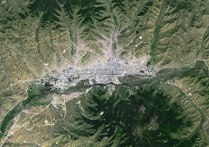
Ulan Bator, Mongolia. Satellite image of Ulan Bator (grey), the capital city of Mongolia. This city lies on the Tuul River (dark, centre) at a height of 1,310 metres in a valley at the foot of the Bogd Khan Uul mountain (dark, lower right). Imaged by the Landsat 8 satellite, on 11th August 2014.
| px | px | dpi | = | cm | x | cm | = | MB |
Details
Creative#:
TOP16630941
Source:
達志影像
Authorization Type:
RM
Release Information:
須由TPG 完整授權
Model Release:
N/A
Property Release:
N/A
Right to Privacy:
No
Same folder images:
1/08/201411august11th201421stcenturyasiaasianbogdkhanuulborderbordersboundariesboundarycapitalcitycartographycitycountriescountryearthobservationenvironmentenvironmentalsciencefromabovefromspacefrontierfrontiersgeographicalgeographylandlandsat8mapmongoliamongolianmountainmountainousmountainsno-onenobodysatelliteimagetuulriverulaanbaatarulanbatorurbanvalley
1/08/20141111th21st82014aboveasiaasianaugustbatorbogdborderbordersboundariesboundarycapitalcartographycenturycitycitycountriescountryearthenvironmentenvironmentalfromfromfrontierfrontiersgeographicalgeographyimagekhanlandlandsatmapmongoliamongolianmountainmountainousmountainsno-onenobodyobservationriversatellitesciencespacetuululaanbaatarulanurbanuulvalley
 Loading