
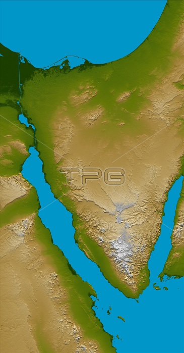
The Sinai Peninsula, located between Africa and Asia, is a result of the two continents pulling apart from each other, creating the two northern branches of the Red Sea, the Gulf of Suez to the west (left), and the Gulf of Aqaba to the east (right). This color-coded shaded relief image shows the triangular nature of the peninsula, with the coast of the Mediterranean Sea forming the northern side of the triangle. The Suez Canal can be seen as the narrow vertical blue line in the upper left connecting the Red Sea to the Mediterranean. Two visualization methods were combined to produce the image: shading and color coding of topographic height. The shade image was derived by computing topographic slope in the northwest-southeast direction, so that northwest slopes appear bright and southeast slopes appear dark. Color coding is directly related to topographic height, with green at the lower elevations, rising through yellow and tan, to white at the highest elevations. Elevation data used in this image were acquired by the Shuttle Radar Topography Mission aboard the Space Shuttle Endeavour, launched on Feb. 11, 2000.
| px | px | dpi | = | cm | x | cm | = | MB |
Details
Creative#:
TOP22083083
Source:
達志影像
Authorization Type:
RM
Release Information:
須由TPG 完整授權
Model Release:
N/A
Property Release:
No
Right to Privacy:
No
Same folder images:
 Loading