
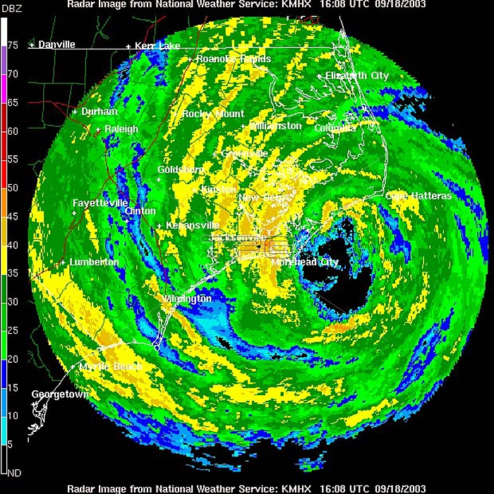
NOAA Morehead City, North Carolina, Doppler radar image for larger view of the outer bands of Hurricane Isabel onshore taken on September 18, 2003, at 12:08 p.m. EDT. Hurricane force winds extend outward up to 115 miles from the center, and tropical storm force winds extend outward up to 345 miles. Hurricane Isabel was the costliest, deadliest, and strongest hurricane in the 2003 Atlantic hurricane season. The ninth named storm, fifth hurricane, and second major hurricane of the season, Isabel formed near the Cape Verde Islands from a tropical wave on September 6 in the tropical Atlantic Ocean. It moved northwestward, and within an environment of light wind shear and warm waters it steadily strengthened to reach peak winds of 165 mph on September 11. After fluctuating in intensity for four days, Isabel gradually weakened and made landfall on the Outer Banks of North Carolina with winds of 105 mph on September 18. It quickly weakened over land and became extratropical over western Pennsylvania the next day. Moderate to severe damage extended up the Atlantic coastline and as far inland as West Virginia. Roughly six million people were left without electric service in the eastern United States from the strong winds of Isabel. Rainfall from the storm extended from South Carolina to Maine, and westward to Michigan. Throughout the path of Isabel, damage totaled about 5.7 billion (2003 USD, $7.31 billion 2014 USD).
| px | px | dpi | = | cm | x | cm | = | MB |
Details
Creative#:
TOP22092809
Source:
達志影像
Authorization Type:
RM
Release Information:
須由TPG 完整授權
Model Release:
N/A
Property Release:
No
Right to Privacy:
No
Same folder images:
 Loading