
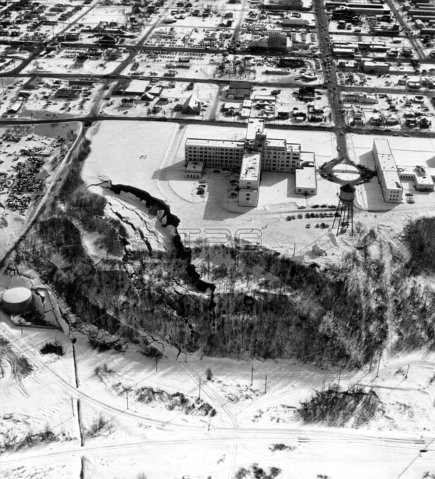
Overhead view of a landslide from the March 27, 1964 Alaska earthquake. The landslide occurred next to this hospital in Anchorage which is showing graben and pressure ridges. Interestingly enough, the scar of an older landslide was transected by this landslide. The 1964 Alaskan earthquake, also known as the Great Alaskan Earthquake, the Portage Earthquake and the Good Friday Earthquake, was a megathrust earthquake that began at 5:36 P.M. AST on Good Friday, March 27, 1964. Lasting nearly four minutes, it was the most powerful recorded earthquake in US and North American history, and the second most powerful ever measured by seismograph. This shock generated a tsunami that devastated many towns along the Gulf of Alaska, and left serious damage at Alberni and Port Alberni, Canada, along the West Coast of the United States (15 killed), and in Hawaii. The maximum wave height recorded was 220 feet at Valdez Inlet. It had a magnitude of 9.2, at the time making it the second largest earthquake in recorded history.
| px | px | dpi | = | cm | x | cm | = | MB |
Details
Creative#:
TOP22093738
Source:
達志影像
Authorization Type:
RM
Release Information:
須由TPG 完整授權
Model Release:
N/A
Property Release:
No
Right to Privacy:
No
Same folder images:
 Loading