
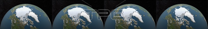
Composite image of the Arctic minimum sea ice in the years 1985, 1995, 2005 and 2015. Satellite-based passive microwave images of the sea ice have provided a reliable tool for continuously monitoring changes in the Arctic ice since 1979. Every summer the Arctic ice cap melts down to what scientists call its "minimum" before colder weather begins to cause ice cover to increase. The ice parameters derived from satellite ice concentration data that are most relevant to climate change studies are sea ice extent and sea ice area.
| px | px | dpi | = | cm | x | cm | = | MB |
Details
Creative#:
TOP22094046
Source:
達志影像
Authorization Type:
RM
Release Information:
須由TPG 完整授權
Model Release:
N/A
Property Release:
No
Right to Privacy:
No
Same folder images:
21stcentury20thcentury2015200519951985compositeimagevisualizationstudiogoddardspaceflightcentergsfcsatelliteimagessatellite-basedannualmeasurementmeasuringminimummonitoringchangespassivemicrowaveimagesseaiceareaseaiceextenticeconcentrationdataiceparametersseaicelevelsarcticicecaparcticicearcticseaicearcticclimatologymeteorologicalmeteorologyclimatologicalclimatechangescience
198519952005201520th21stannualarcticarcticarcticarcticareacapcentercenturycenturychangechangesclimateclimatologicalclimatologycompositeconcentrationdataextentflightgoddardgsfciceiceiceiceiceiceiceiceimageimagesimageslevelsmeasurementmeasuringmeteorologicalmeteorologymicrowaveminimummonitoringparameterspassivesatellitesatellite-basedscienceseaseaseaseaspacestudiovisualization
 Loading