
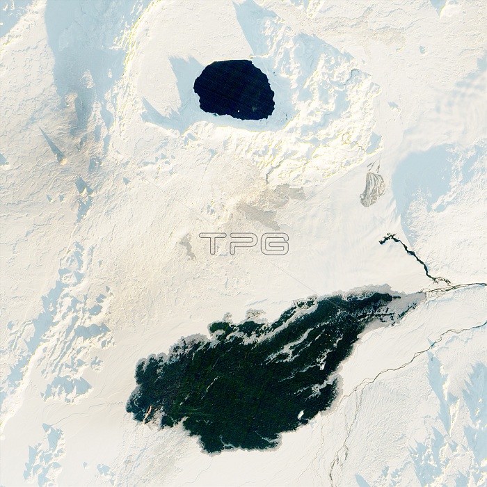
Holuhraun lava field in Iceland, captured by the Advanced Land Imager on NASA's Earth Observing-1 satellite at 10:00 a.m. local time, on November 5, 2016. The 2014-15 eruption was the largest basaltic lava flow in Iceland since 1783-84, spreading across 84 square kilometers (32 square miles). More than a year after the eruption, the lava is still too warm to accumulate snow. The round feature above the lava is Askja caldera. The photo has been edited to correct for the low angle of the sun.
| px | px | dpi | = | cm | x | cm | = | MB |
Details
Creative#:
TOP22096282
Source:
達志影像
Authorization Type:
RM
Release Information:
須由TPG 完整授權
Model Release:
N/A
Property Release:
No
Right to Privacy:
No
Same folder images:
earthobserving-1advancedlandimagervolcanicactivityvolcanologyvolcanismdifferentsurfacereflectivityalbedowhitesnowdarkrockheatabsorbentlavacruststillwarmnewly-formedlavaplaincalderaaskjageography2016imageryobservationphotosatellitephotographyaerialearthfromspaceearthsciencelandscapelandformgeologicalgeologicformationgeologyicelandicigneousbasalticrockvolcanicfissureeruptionlavaflowaerialviewsatelliteimageholuhraunicelandlavafield
2016absorbentactivityadvancedaerialaerialalbedoaskjabasalticcalderacrustdarkdifferenteartheartheartheruptionfieldfissureflowformationfromgeographygeologicgeologicalgeologyheatholuhraunicelandicelandicigneousimageimagerimagerylandlandformlandscapelavalavalavalavanewly-formedobservationobserving-1photophotographyplainreflectivityrockrocksatellitesatellitesciencesnowspacestillsurfaceviewvolcanicvolcanicvolcanismvolcanologywarmwhite
 Loading