
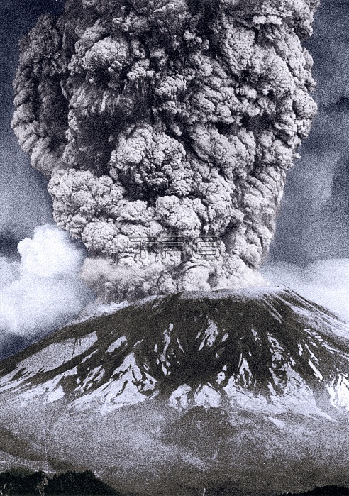
Mount St. Helens, Washington, is the most active volcano in the Cascade Range. The first sign of activity at Mount St. Helens in the spring of 1980 was a series of small earthquakes that began on March 16. Steam explosions on March 27 blasted a crater through the volcano's summit ice cap. Within a week the crater had grown to about 1,300 feet in diameter and two giant crack systems crossed the entire summit area. By May 17, more than 10,000 earthquakes had shaken the volcano and the north flank had grown outward at least 450 feet to form a noticeable bulge. Such dramatic deformation of the volcano was strong evidence that molten rock (magma) had risen high into the volcano. Within 15 to 20 seconds of a magnitude 5.1 earthquake on May 18th, at 8:32 a.m., the volcano's bulge and summit slid away in a huge landslide - the largest on Earth in recorded history. Rocks, ash, volcanic gas, and steam were blasted upward and outward to the north. This lateral blast of hot material accelerated to at least 300 miles per hour, then slowed as the rocks and ash fell to the ground and spread away from the volcano. The blast cloud traveled as far as 17 miles northward from the volcano and the landslide traveled about 14 miles west down the North Fork Toutle River. No photographer credited, undated.
| px | px | dpi | = | cm | x | cm | = | MB |
Details
Creative#:
TOP22096406
Source:
達志影像
Authorization Type:
RM
Release Information:
須由TPG 完整授權
Model Release:
N/A
Property Release:
No
Right to Privacy:
No
Same folder images:
 Loading