
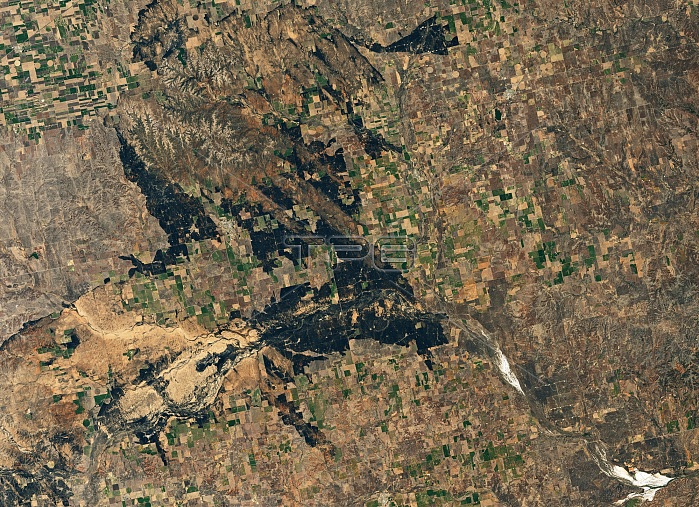
The area around Ashland, Kansas, burned by the Starbuck Fire in March, 2017. Photo taken by the Operational Land Imager (OLI) on Landsat 8 on March 17, 2017.
| px | px | dpi | = | cm | x | cm | = | MB |
Details
Creative#:
TOP22096562
Source:
達志影像
Authorization Type:
RM
Release Information:
須由TPG 完整授權
Model Release:
N/A
Property Release:
No
Right to Privacy:
No
Same folder images:
environmentalscienceenvironmentlandscapegeographynaturaldisastergrazinglandnorthwestoklahomacomplexfires2017imageryphotoobservationsatellitephotographyaerialearthfromspaceoperationallandimagerolilandsat8landsatnorthamericaamericanplainsusausunitedstateskansasfarmplotfarmlandafterfirecharredlandburntareaburneddamageforestfirewildfirewildfireaerialviewsatelliteimagestarbuckfireashlandkansasfireaftermath
82017aerialaerialafteraftermathamericaamericanareaashlandburnedburntcharredcomplexdamagedisasterearthenvironmentenvironmentalfarmfarmlandfirefirefirefirefirefiresforestfromgeographygrazingimageimagerimagerykansaskansaslandlandlandlandsatlandsatlandscapenaturalnorthnorthwestobservationoklahomaolioperationalphotophotographyplainsplotsatellitesatellitesciencespacestarbuckstatesunitedususaviewwildwildfire
 Loading