
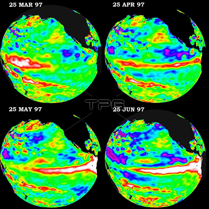
These four views of the Pacific Ocean were produced using sea surface height measurements taken by the US/French TOPEX/POSEIDON satellite. The images show sea surface height relative to normal ocean conditions from March 1997 through June 1997. This evolutionary view is providing oceanographers with more convincing information that the weather-disrupting phenomenon known as El Ni簽o is back and getting stronger. The white and red areas indicate unusual patterns of heat storage; in the white areas, the sea surface is between 6 to 13 inches above normal; in the red areas, it s about 4 inches above normal. The surface area covered by the warm water mass is about one and one-half times the size of the continental US. The added amount of oceanic warm water near the Americas, with a temperature between 70-85 degrees Fahrenheit, is about 30 times the volume of water in all the US Great Lakes combined. The green areas indicate normal conditions, while purple (the western Pacific) means at least 7 inches below normal sea level.
| px | px | dpi | = | cm | x | cm | = | MB |
Details
Creative#:
TOP22301278
Source:
達志影像
Authorization Type:
RM
Release Information:
須由TPG 完整授權
Model Release:
N/A
Property Release:
No
Right to Privacy:
No
Same folder images:
 Loading