
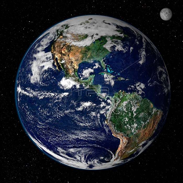
Earth from space. This true-color image shows North and South America as they would appear from space 35,000 km (22,000 miles) above Earth. The image is a combination of data from two satellites. The Moderate Resolution Imaging Spectroradiometer) instrument aboard NASA's Terra satellite collected the land surface data over 16 days, while NOAA's Geostationaryle erational Environmental Satellite (GOES) produced a snapshot of the Earth's clouds.
| px | px | dpi | = | cm | x | cm | = | MB |
Details
Creative#:
TOP22309926
Source:
達志影像
Authorization Type:
RM
Release Information:
須由TPG 完整授權
Model Release:
N/A
Property Release:
No
Right to Privacy:
No
Same folder images:
moderateresolutionimagingspectroradiometerearthobservingsatelliteeosterramodissatelliteimagerymeteorologyweatherweathersatellitesweathersatellitenasaplanetsplanetsphereworldglobestarsatelliteimageearthimagewholeearthgeosphereimagesgeosphereimagewesternhemispherecontinentssouthamericanorthamericastarsearthearthobservationsatelliteimagesearthimagesearthgraphicsearthfromspaceamericas
americaamericaamericascontinentseartheartheartheartheartheartheartheartheosfromgeospheregeosphereglobegraphicshemisphereimageimageimageimageryimagesimagesimagesimagingmeteorologymoderatemodisnasanorthobservationobservingplanetplanetsresolutionsatellitesatellitesatellitesatellitesatellitesatellitessouthspacespectroradiometerspherestarstarsterraweatherweatherweatherwesternwholeworld
 Loading