
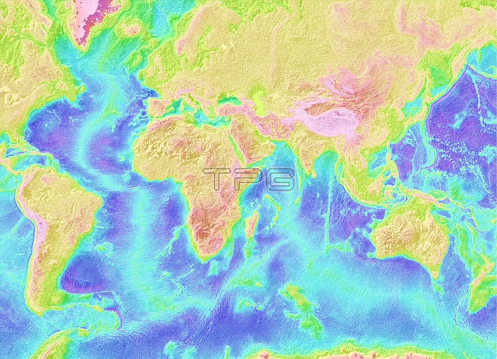
Marine Geology & Geophysics. Global seafloor topography from Satellite Altimetry readings of the Atlantic and Indian Ocean. Seafloor topography data were collated in 1997 by Smith and Sandwell. Color-coding shows the variation in the depth of the sea floor. On the map blue indicates ocean depths, while green indicates underwater mountain ranges and peaks. Land topography is shown with orange being low-lying areas and red being plateaus and mountain ranges.
| px | px | dpi | = | cm | x | cm | = | MB |
Details
Creative#:
TOP22312590
Source:
達志影像
Authorization Type:
RM
Release Information:
須由TPG 完整授權
Model Release:
N/A
Property Release:
No
Right to Privacy:
No
Same folder images:
datamarinefaultsfaultvolcanictectonicplatesseismologyseismic20thcentury1997earthfromspaceearthnorthamericasouthamericaafricaeuropeasiaaltimeteraltimetrysatelliteseafloorseafloorplateauplateaussandwellsmithmountainsmountainmountainrangesoceanographylandtopographytopographymaptopographicmaptopographicoceanatlanticindianatlanticoceanindianoceangeologygeophysicsmarinegeologyscience
199720thafricaaltimeteraltimetryamericaamericaasiaatlanticatlanticcenturydataeartheartheuropefaultfaultsfloorfromgeologygeologygeophysicsindianindianlandmapmapmarinemarinemountainmountainmountainsnorthoceanoceanoceanoceanographyplateauplateausplatesrangessandwellsatellitescienceseaseafloorseismicseismologysmithsouthspacetectonictopographictopographictopographytopographyvolcanic
 Loading