
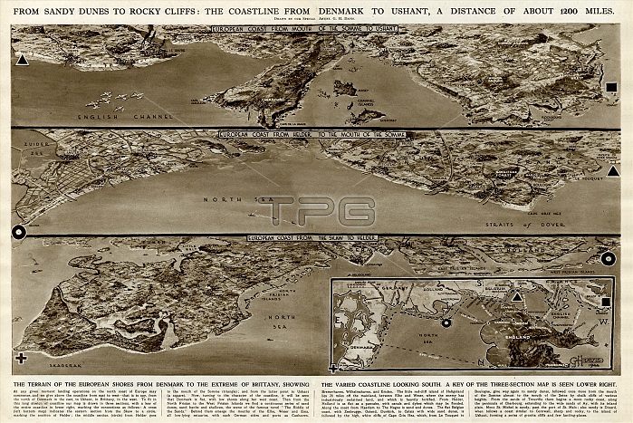
From sandy dunes to rocky cliffs: the coastline from Denmark to Ushant (Brittany), a distance of about 1200 miles. The terrain of the European shores from Denmark to the extreme of Brittany, showing the varied coastline looking south. A key of the three-section map can be seen in the lower right.
| px | px | dpi | = | cm | x | cm | = | MB |
Details
Creative#:
TOP23848488
Source:
達志影像
Authorization Type:
RM
Release Information:
須由TPG 完整授權
Model Release:
No
Property Release:
No
Right to Privacy:
No
Same folder images:
sandydunesrockycliffscoastcoastlinelandseadenmarkushantbrittanyfrancedanishfrencheuropedistance1200milesterraineuropeanshoresextremevariedlookingsouthkeythreesectionmapmaps1944englishchannelnorthskagerakstraitsdoverislandsjerseyguernseyhollandnetherlandsbelgiumgermanygeorgehoracedavisghhistoryhistorical
12001944belgiumbrittanychannelcliffscoastcoastlinedanishdavisdenmarkdistancedoverdunesenglisheuropeeuropeanextremefrancefrenchggeorgegermanyguernseyhhistoricalhistoryhollandhoraceislandsjerseykeylandlookingmapmapsmilesnetherlandsnorthrockysandyseasectionshoresskageraksouthstraitsterrainthreeushantvaried
 Loading