
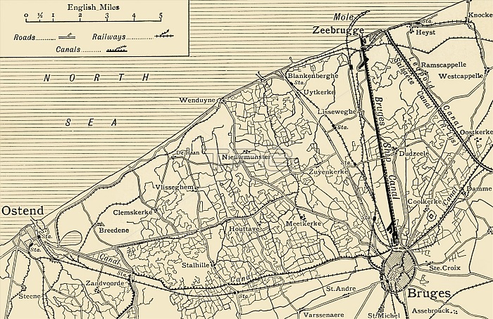
'Map showing the Canal System connecting Zeebrugge and Ostend with Bruges', First World War, (c1920). The Belgian ports of Ostend and Zeebrugge were connected to the city of Bruges via canals. From "The Great World War: A History", Volume IX, edited by Frank A Mumby. [The Gresham Publishing Company Ltd, London, c1920]
| px | px | dpi | = | cm | x | cm | = | MB |
Details
Creative#:
TOP25460499
Source:
達志影像
Authorization Type:
RM
Release Information:
須由TPG 完整授權
Model Release:
No
Property Release:
No
Right to Privacy:
No
Same folder images:
transporttransportationseacoastcoastalcoastlinebookgeographyBrugesFlandersBelgiumcanalcanalswarcenturynetworkfirstworldwarconceptNorthSeaWorldWarIWWIwatertransportB/WWorldWarOne1910s20thcenturyThePrintCollector1stWorldWargeographicalfeatureTGNWW1OstendemapUnknownZeebruggeKeystoneArchivesOstendtheatreofwarTheGreatWorldWar:AHistoryFrankArthurMumbyMumbyFrankArthurGreshamPublishingCompanyGreshamPublishingCoLtdFrankAMumbyFrankA.MumbyFrankA.FrankA
1910s1st20thAAAA.A.ArchivesArthurArthurB/WBelgiumBrugesCoCollectorCompanyFlandersFrankFrankFrankFrankFrankFrankGreatGreshamGreshamHistoryIKeystoneLtdMumbyMumbyMumbyMumbyNorthOneOstendOstendePrintPublishingPublishingSeaTGNTheTheUnknownWW1WWIWarWarWarWar:WorldWorldWorldWorldZeebruggebookcanalcanalscenturycenturycoastcoastalcoastlineconceptfeaturefirstgeographicalgeographymapnetworkofseatheatretransporttransporttransportationwarwarwarwaterworld
 Loading