
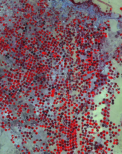
Centre-pivot irrigation in Saudi Arabia, infrared satellite image. The circular fields here are irrigated by water brought to the desert surface from the Wajid Aquifer in Saudi Arabia and Yemen. This area is near Wadi Al Dawasir, Saudi Arabia. Heavy use of water has reduced the level in the aquifer system by 6 metres a year for the past 20 to 30 years, with exhaustion of the aquifer in some areas. This image covers an area of 34 by 44 kilometres. It was acquired on 26 April 2017 by the ASTER (Advanced Spaceborne Thermal Emission and Reflection Radiometer) sensor on the Terra satellite.
| px | px | dpi | = | cm | x | cm | = | MB |
Details
Creative#:
TOP25529485
Source:
達志影像
Authorization Type:
RM
Release Information:
須由TPG 完整授權
Model Release:
N/A
Property Release:
N/A
Right to Privacy:
No
Same folder images:
 Loading