
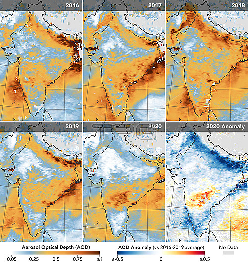
Satellite data map of airborne particle density (aerosol optical depth, AOD) over India between March 31st and April 5th for the years 2016 to 2019. The 2020 map (bottom right) is the comparison of the data for 2020, during the 2019-20 Covid-19 outbreak, with the 2016-19 average. Airborne particles are produced by the combustion of fossil fuels by industry and transport, and the burning of vegetation. Lockdowns to stop the spread of the new coronavirus, SARS-Cov-2, that is the cause of Covid-19 have lead to a reduction in particulate pollution in northern India to the lowest level for 20 years. Data obtained by the Moderate Resolution Imaging Spectroradiometer (MODIS) on NASA?檚 Terra satellite.
| px | px | dpi | = | cm | x | cm | = | MB |
Details
Creative#:
TOP25663304
Source:
達志影像
Authorization Type:
RM
Release Information:
須由TPG 完整授權
Model Release:
N/A
Property Release:
N/A
Right to Privacy:
No
Same folder images:
 Loading