
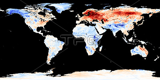
Global warming record. Satellite map of land surface temperature anomalies for January 2020, the warmest January on record. Global land and ocean surface temperatures were 1.14 degrees Celsius above the 20th century average. This map shows where Earth's surface was warmer or cooler in the daytime than the average temperatures for the same week or month from 2001-2010. Red is warmer than average, white is normal, and blue is cooler than average. The observations were collected by the Moderate Resolution Imaging Spectroradiometer (MODIS) on NASA's Terra satellite.
| px | px | dpi | = | cm | x | cm | = | MB |
Details
Creative#:
TOP25747073
Source:
達志影像
Authorization Type:
RM
Release Information:
須由TPG 完整授權
Model Release:
N/A
Property Release:
N/A
Right to Privacy:
No
Same folder images:
202021stcenturyanomaliesblackbackgroundclimatechangeclimatologicalclimatologyearthfromspaceglobalwarmingheatwavelandsurfacetemperatureanomalymeteorologicalmeteorologymoderateresolutionimagingspectroradiometermodisno-onenobodyplanetrecordrecordbreakingsatellitesatelliteimagesatellitemapterrawarmestsincerecordsbeganweatherworldmpahottestjanuary
202021stanomaliesanomalybackgroundbeganblackbreakingcenturychangeclimateclimatologicalclimatologyearthfromglobalheatwavehottestimageimagingjanuarylandmapmeteorologicalmeteorologymoderatemodismpano-onenobodyplanetrecordrecordrecordsresolutionsatellitesatellitesatellitesincespacespectroradiometersurfacetemperatureterrawarmestwarmingweatherworld
 Loading