
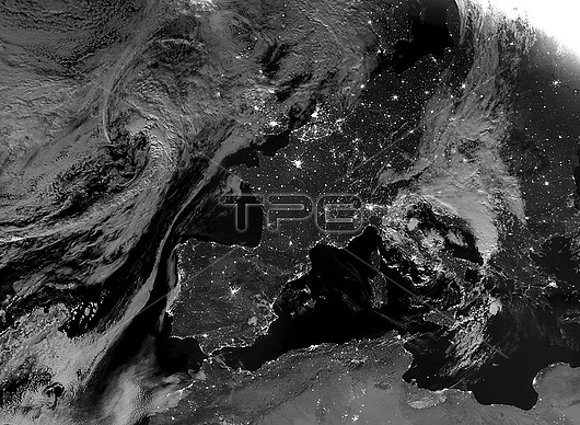
Western Europe at night, satellite image. More densely populated areas are brighter. Data acquired by the day-night band of the Visible Infrared Imaging Radiometer Suite (VIIRS) on board the NASA-NOAA Suomi National Polar-orbiting Partnership (NPP) satellite, on 5th August 2020.
| px | px | dpi | = | cm | x | cm | = | MB |
Details
Creative#:
TOP25967458
Source:
達志影像
Authorization Type:
RM
Release Information:
須由TPG 完整授權
Model Release:
N/A
Property Release:
N/A
Right to Privacy:
No
Same folder images:
2000s2020s202021stcenturyatlanticoceanblackmarblebritishcitiescityearthobservationelectricityenergyuseeuropeanfromspacegreatbritainhabitationilluminateilluminationlandlightlightpollutionlightsnightnightlightsnighttimenight-timepopulationdensityruralsatelliteimageseasuominationalpolar-orbitingpartnershipsuominppurbanviirsvisibleinfraredimagingradiometersuite5august2020europewesternspainiberianpeninsulafrancegermanyitalycloudsblackandwhite.monochromenobodyfrenchno-onemediterraneanseanorthafrica
2000s202020202020s21st5africaandatlanticaugustblackblackbritainbritishcenturycitiescitycloudsdensityearthelectricityenergyeuropeeuropeanfrancefrenchfromgermanygreathabitationiberianilluminateilluminationimageimaginginfrareditalylandlightlightlightslightsmarblemediterraneanmonochromenationalnightnightnightnight-timeno-onenobodynorthnppobservationoceanpartnershippeninsulapolar-orbitingpollutionpopulationradiometerruralsatelliteseaseaspacespainsuitesuomisuomitimeurbanuseviirsvisiblewesternwhite.
 Loading