
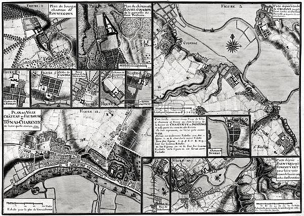
XDT182051 Fol.7 & 98 Map of the towns and chateaux situated along the Charente River in 1714, from \'Recueil des Plans de Saintonge\' (pen & ink and w/c on paper) (b/w photo) by Masse, Claude (1652-1737); Min. Defense - Service Historique de l\'Armee de Terre,France; French, out of copyright.
| px | px | dpi | = | cm | x | cm | = | MB |
Details
Creative#:
TOP26819431
Source:
達志影像
Authorization Type:
RM
Release Information:
須由TPG 完整授權
Model Release:
No
Property Release:
No
Right to Privacy:
No
Same folder images:
castlecastlesdwellinghousingaccomodationaerialviewchateauregionforestcandesprovinceofwesternfrancefieldsmaptownvalleyagonaysaintesbussaclarivierechampsteurchandolantonai-charenteplancresanepontdetaillebourgroumegouxfoncouvertroche-courbonPaintingMzpaintingaerialviewchateauregionforestcandesprovinceofwesternfrancefieldsmaptownvalleyagonaysaintesbussaclarivierechampsteurchandolantonai-charenteplancresanepontdetaillebourgroumegouxfoncouvertroche-courbon
MzpaintingPaintingaccomodationaerialaerialagonayagonaybussacbussaccandescandescastlecastleschampsteurchampsteurchandolanchandolanchateauchateaucresanecresanedededwellingfieldsfieldsfoncouvertfoncouvertforestforestfrancefrancehousinglalamapmapofofplanplanpontpontprovinceprovinceregionregionriviereriviereroche-courbonroche-courbonroumegouxroumegouxsaintessaintestaillebourgtaillebourgtonai-charentetonai-charentetowntownvalleyvalleyviewviewwesternwestern
 Loading