
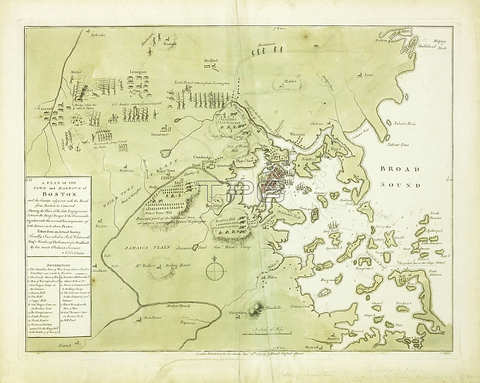
985758 A Plan of the Town and Harbour of Boston and the Country adjacent\' (with locations of the battles of Concord and Lexington, 19th April, 1775), 1775 (hand-coloured engraved map) by English School, (18th century); 38.3x49.8 cm; Private Collection; (add.info.: \'A Plan of the Town and Harbour of Boston and the Country adjacent...\' (with locations of the battles of Concord and Lexington, 19th April, 1775), by J. de Costa. English School, (18th century). Hand-coloured engraved map. Published in London, 6th December, 1775. 38.3 x 49.8cm.); Photo 穢 Christie\'s Images.
| px | px | dpi | = | cm | x | cm | = | MB |
Details
Creative#:
TOP27250920
Source:
達志影像
Authorization Type:
RM
Release Information:
須由TPG 完整授權
Model Release:
No
Property Release:
No
Right to Privacy:
No
Same folder images:
battleconfrontationfightconflictclashconfronteachotherfightagainstfightingcoastseacartographyartistbritishharboursoldiercountryclose-upurbanhandcolouredobjectenglishartenemiesprofessionruralgreennopersoncoastlinenegativeconceptprinthand-tintedhumanlikenesscloseupmilitaryrankoneobjectnaturalspacelateeighteenthcenturyhandcoloringlandnavigationalequipmentshorelinemilitaryarmedforcesdrawingeighteenthcenturyletteringcloseup18thcenturycolorcomradehandcoloredenglishtextconflicteuropeanartistno-onefighterwordhand-coloredtextadjacentoccupationnorthamericasealocationprintshandcolouredrepresentationinsidestrifeindoorscountrysidewatertransportlate18thcenturystudioshothuman-likegeographicgreencolourartisteuropeanmapgeographyillustratedwatertownpublishedsingleobjectfighting1770sdetailharboramericabritishartistindoornobodyhand-colouringfightnopeoplewritinghand-colouredshorehandcoloredenglishartistuscartographerengravedprecisionengravingcapitalletterunitedstatescolourenglishschooltransportationlanguagehandcolouringmilitarypositionillustrationtransportdesignusacostaplanstudio1775massachusettsbostonartistbritishharboursoldiercountryclose-upurbanhandcolouredobjectenglishartenemiesprofessionruralgreennopersoncoastlinenegativeconceptprinthand-tintedhumanlikenesscloseupmilitaryrankoneobjectnaturalspacelateeighteenthcenturyhandcoloringlandnavigationalequipmentshorelinemilitaryarmedforcesdrawingeighteenthcenturyletteringcloseup18thcenturycolorcomradehandcoloredenglishtextconflicteuropeanartistno-onefighterwordhand-coloredtextadjacentoccupationnorthamericasealocationprintshandcolouredrepresentationinsidestrifeindoorscountrysidewatertransportlate18thcenturystudioshothuman-likegeographicgreencolourartisteuropeanmapgeographyillustratedwatertownpublishedsingleobjectfighting1770sdetailharboramericabritishartistindoornobodybattlehand-colouringfightnopeoplewritinghand-colouredcoastalshorehandcoloredenglishartistuscartographerengravedprecisionengravingcapitalletterunitedstatescolourenglishschooltransportationlanguagehandcolouringcoastmilitarypositionillustrationtransportdesignusacostaplanstudio1775massachusettsboston
1770s1770s1775177518th18th18th18thadjacentadjacentagainstamericaamericaamericaamericaarmedarmedartartartistartistartistartistartistartistartistartistartistartistbattlebattlebostonbostonbritishbritishbritishbritishcapitalcapitalcartographercartographercartographycenturycenturycenturycenturycenturycenturycenturycenturyclashclosecloseclose-upclose-upcloseupcloseupcoastcoastcoastalcoastlinecoastlinecolorcolorcoloredcoloredcoloringcoloringcolourcolourcolourcolourcolouredcolouredcolouringcolouringcomradecomradeconceptconceptconflictconflictconflictconfrontconfrontationcostacostacountrycountrycountrysidecountrysidedesigndesigndetaildetaildrawingdrawingeacheighteentheighteentheighteentheighteenthenemiesenemiesenglishenglishenglishenglishenglishenglishenglishenglishengravedengravedengravingengravingequipmentequipmenteuropeaneuropeaneuropeaneuropeanfightfightfightfightfighterfighterfightingfightingfightingforcesforcesgeographicgeographicgeographygeographygreengreengreengreenhandhandhandhandhandhandhandhandhand-coloredhand-coloredhand-colouredhand-colouredhand-colouringhand-colouringhand-tintedhand-tintedhandcoloredhandcoloredhandcolouredhandcolouredharborharborharbourharbourhumanhumanhuman-likehuman-likeillustratedillustratedillustrationillustrationindoorindoorindoorsindoorsinsideinsidelandlandlanguagelanguagelatelatelatelateletterletterletteringletteringlikenesslikenesslocationlocationmapmapmassachusettsmassachusettsmilitarymilitarymilitarymilitarymilitarymilitarynaturalnaturalnavigationalnavigationalnegativenegativenonononono-oneno-onenobodynobodynorthnorthobjectobjectobjectobjectobjectobjectoccupationoccupationoneoneotherpeoplepeoplepersonpersonplanplanpositionpositionprecisionprecisionprintprintprintsprintsprofessionprofessionpublishedpublishedrankrankrepresentationrepresentationruralruralschoolschoolseaseaseashoreshoreshorelineshorelineshotshotsinglesinglesoldiersoldierspacespacestatesstatesstrifestrifestudiostudiostudiostudiotexttexttexttexttowntowntransporttransporttransporttransporttransportationtransportationunitedunitedupupurbanurbanusususausawaterwaterwaterwaterwordwordwritingwriting
 Loading