
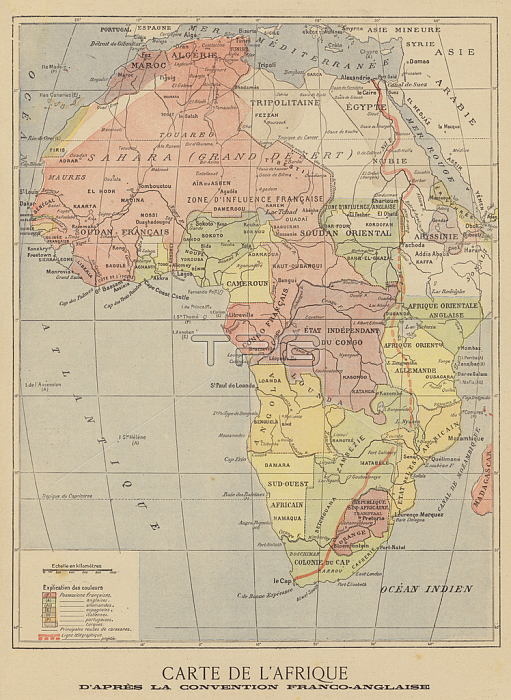
2819021 Map of Africa after the signing of the Anglo-French Agreement of March 1899 (colour litho) by French School, (19th century); Private Collection; (add.info.: Map of Africa after the signing of the Anglo-French Agreement of March 1899. The agreement stipulated that French colonial expansion eastwards in Africa would stop at the watershed of the Nile. Carte de l\'Afrique d\'apres la convention Franco-Anglaise. Illustration for Le Petit Journal, 9 April 1899.); 穢 Look and Learn.
| px | px | dpi | = | cm | x | cm | = | MB |
Details
Creative#:
TOP27499832
Source:
達志影像
Authorization Type:
RM
Release Information:
須由TPG 完整授權
Model Release:
No
Property Release:
No
Right to Privacy:
No
Same folder images:
diplomacyboundaryempireagreementimperialismafricafrenchcoloniescolonialismforeignrelations19thcenturybritishmapscrambleforafricageographypoliticsspheresofinfluencebritiaindivisionfranceboundaryempireagreementimperialismafricafrenchcoloniescolonialismforeignrelations19thcenturybritishmapscrambleforafricageographypoliticsspheresofinfluencebritiaindivisionfrance
19th19thafricaafricaafricaafricaagreementagreementboundaryboundarybritiainbritiainbritishbritishcenturycenturycolonialismcolonialismcoloniescoloniesdiplomacydivisiondivisionempireempireforforforeignforeignfrancefrancefrenchfrenchgeographygeographyimperialismimperialisminfluenceinfluencemapmapofofpoliticspoliticsrelationsrelationsscramblescramblespheresspheres
 Loading