
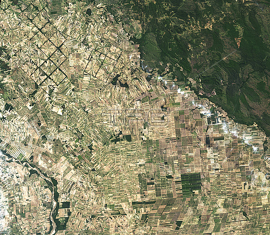
Satellite image showing radial patterns of deforestation in Bolivia, where Chiquitano dry forests in Tierras Bajas region, east of Santa Cruz have been cleared for agricultural use. Since the 1980s, this region has been rapidly deforested due to the relatively flat lowlands and abundant rainfall that make it suitable for farming. Image obtained by the Operation Land Imager (OLI) on the Landsat 8 satellite on the 22nd of August 2022.
| px | px | dpi | = | cm | x | cm | = | MB |
Details
Creative#:
TOP28328413
Source:
達志影像
Authorization Type:
RM
Release Information:
須由TPG 完整授權
Model Release:
N/A
Property Release:
N/A
Right to Privacy:
No
Same folder images:
22ndaugust2022agriculturalagricultureboliviaclearingclimatechangeclimatologicalclimatologydeforestedearthscienceenvironmentenvironmentalfarmingfarmsforestchangeforestlossfromabovefromspacegeographicalgeographyglobalwarmingland-uselandsatlatinamericamoderateresolutionimagingspectroradiometermodisno-onenobodypatternspinwheelpinwheelradialsantacruzsatelliteimagesouthamericasouthamericantierrasbajaslandsat8
202222nd8aboveagriculturalagricultureamericaamericaamericanaugustbajasboliviachangechangeclearingclimateclimatologicalclimatologycruzdeforestedearthenvironmentenvironmentalfarmingfarmsforestforestfromfromgeographicalgeographyglobalimageimagingland-uselandsatlandsatlatinlossmoderatemodisno-onenobodypatternspinpinwheelradialresolutionsantasatellitesciencesouthsouthspacespectroradiometertierraswarmingwheel
 Loading