
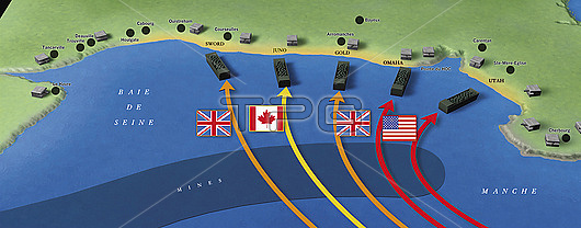
Map of the D-Day landings,, 1944, illustration. The D-Day landings of 6 June 1944 were the largest seaborne invasion in history. Over 5000 vessels transported an Allied force of some 156,000 troops across the English Channel They successfully liberated the Normandy coast of Nazi-occupied France, contributing to the Allied victory in World War II.
| px | px | dpi | = | cm | x | cm | = | MB |
Details
Creative#:
TOP29027475
Source:
達志影像
Authorization Type:
RM
Release Information:
須由TPG 完整授權
Model Release:
Not Available
Property Release:
Not Available
Right to Privacy:
No
Same folder images:
1900s1940s194420thcentury6june1944alliedalliesamericaamericanarmybattlebeachbritainbritishcanadacanadiancoastcoastalddayd-dayenglishchanneleuropeeuropeanflagflagsfrancefrenchgoldhistoricalhistoryinvadinginvasionjunejunolabellabeledlabelledlabelslandinglandingsmapmaritimemilitarynavalno-onenobodynormandyomahaseaseabornesecondworldwarshipshipsswordtextunitedstatesususautahwarwarfareworldwar2worldwariiworldwartwoww2wwii
1900s1940s261944194420thalliedalliesamericaamericanarmybattlebeachbritainbritishcanadacanadiancenturychannelcoastcoastaldd-daydayenglisheuropeeuropeanflagflagsfrancefrenchgoldhistoricalhistoryiiinvadinginvasionjunejunejunolabellabeledlabelledlabelslandinglandingsmapmaritimemilitarynavalno-onenobodynormandyomahaseaseabornesecondshipshipsstatesswordtexttwounitedususautahwarwarwarwarwarwarfareworldworldworldworldww2wwii
 Loading