
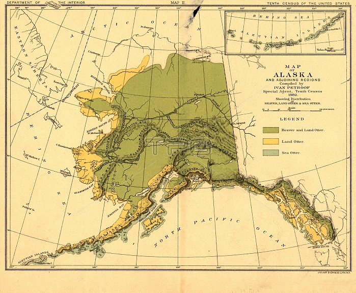
Map of Alaska and adjoining regions, 1882. This multi-sheet map was produced by Ivan Petroff (also seen as Petroof and Petrof), a U.S. Census agent, in 1882, 15 years after Russias sale of Alaska to the United States. The sheets of this map show the zoogeography of Alaska for various animals, including the typical range for land otter, sea otter, polar bear, brown bear, black bear, red fox, cross fox, black (silver) fox, white and blue Arctic foxes, mink, and marten. The maps use a variety of colors to highlight specific species for easy reference to their habitat and distribution across the region. They also provide ecological information, for example concerning the crisis stemming from the precipitous regional decline of the sea otter. The Russian American Company had severely overhunted this marine mammal for more than a century, owing to the enormous value of its fur, and the relevant map in this set reveals the reduced range of the sea otter in the early American period. Each map assesses related groups of animals and uses unique colors for each species. The maps also include basic geographical information, such as the names of mountain ranges as well as key rivers and bodies of water.
| px | px | dpi | = | cm | x | cm | = | MB |
Details
Creative#:
TOP29694914
Source:
達志影像
Authorization Type:
RM
Release Information:
須由TPG 完整授權
Model Release:
Not Required
Property Release:
Not Required
Right to Privacy:
No
Same folder images:
 Loading