
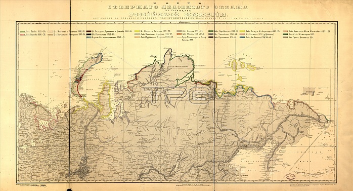
Karta Si?e?vernago Ledovitago okeana v granit?s?akh Rossi¡Âi?skoi? Imperi¡Âi : sostavlena na osnovani¡Âi russkikh gidrograficheskikh izsli?e?dovani¡Âi? s 1734 po 1871 god, 1874. Hand col. in watercolors to show northern Russian coastline with explorers/surveyers names and dates of survey for each section. "Popolnena i pechatana s kamni?a? v 1874 g."
| px | px | dpi | = | cm | x | cm | = | MB |
Details
Creative#:
TOP29694955
Source:
達志影像
Authorization Type:
RM
Release Information:
須由TPG 完整授權
Model Release:
Not Required
Property Release:
Not Required
Right to Privacy:
No
Same folder images:
oceannorthcoastlibraryhistoricaldiscoveryartscoastalmapcountrycoastlineexplorationartgeographycolornortherndirectiontextlocationcenturyRussiaRussianexploringcartographyconceptlegendsurveyArcticOceandiscoveringletteringhand-tintedwatercolourLibraryofCongressColour19thcenturyCyrillic1870shandtintednineteenthcenturyhistoryhistoricgeographicalfeaturemap-makingTGNhandcolouredmapMapmakingUnknownCongressionalLibraryhand-colouredHeritageArt19th-centurycartographicMeetingofFrontiers
1870s19th19th-centuryArcticArtColourCongressCongressionalCyrillicFrontiersHeritageLibraryLibraryMapmakingMeetingOceanRussiaRussianTGNUnknownartartscartographiccartographycenturycenturycenturycoastcoastalcoastlinecolorcolouredconceptcountrydirectiondiscoveringdiscoveryexplorationexploringfeaturegeographicalgeographyhandhandhand-colouredhand-tintedhistorichistoricalhistorylegendletteringlibrarylocationmapmapmap-makingnineteenthnorthnorthernoceanofofsurveytexttintedwatercolour
 Loading