
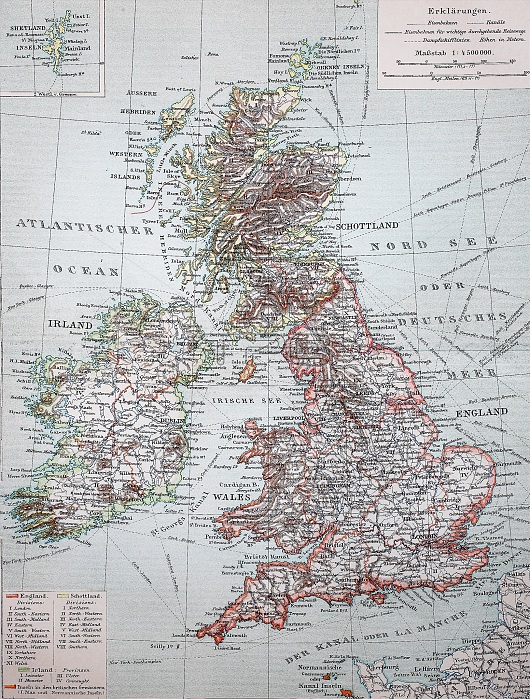
Landkarte von Grossbritannien und Irland, 1895, Map of Great Britain and Ireland, 1895, digital improved reproduction of an original print from the year 1895
| px | px | dpi | = | cm | x | cm | = | MB |
Details
Creative#:
TOP25182213
Source:
達志影像
Authorization Type:
RM
Release Information:
須由TPG 完整授權
Model Release:
No
Property Release:
No
Right to Privacy:
No
Same folder images:
englandgreatbritainirelandunitedkingdommapgeographyroadmap4992690alteHolzschnitteoldhistorichistoricalillustrationwoodcutwood-cutblackwhiteblackandwhiteheritagevintagereproreproduction19thcenturyHistorischagedartartpieceartpiecesblack-and-whitedrawingdrawingshistoricillustrationhistoricallyillustrationsobjectobjectsobjetobjetspiecepiecespresentationpresentationsrepresentationrepresentationssketchesworkworkswoodcutsreproductions
19th4992690HistorischHolzschnitteagedalteandartartpieceartpiecesblackblackblack-and-whitebritaincenturydrawingdrawingsenglandgeographygreatheritagehistorichistorichistoricalhistoricallyillustrationillustrationillustrationsirelandkingdommapmapobjectobjectsobjetobjetsoldpiecepiecespresentationpresentationsrepresentationrepresentationsreproreproductionreproductionsroadsketchesunitedvintagewhitewhitewood-cutwoodcutwoodcutsworkworks
 Loading