
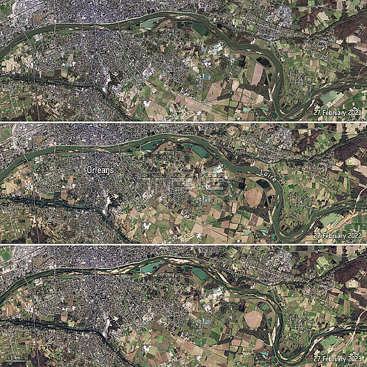
Satellite images of the Loire River, near Orleans, France on the 27th February 2021 (top), 2022 (middle) and 2023 (bottom). There are large areas of exposed riverbed in the image from 2023 due to drought. The drought was caused by the second warmest winter on record with low levels of rainfall. Data obtained by the Copernicus Sentinel-2 satellite.
| px | px | dpi | = | cm | x | cm | = | MB |
Details
Creative#:
TOP28948669
Source:
達志影像
Authorization Type:
RM
Release Information:
須由TPG 完整授權
Model Release:
n/a
Property Release:
n/a
Right to Privacy:
No
Same folder images:
Restriction:
This image may not be used to state or imply ESA endorsement of any company or product
2000s2020s20212022202321stcentury27februaryclimateclimatechangeclimatecrisisclimateemergencycomparingcomparisoncopernicussentinel-2drieddroughtdryenvironmenteuropeeuropeanfrancefrenchfromspaceglobalwarminghydrologylabellabeledlabelledlabelsloiremeteorologicalmeteorologyno-onenobodyorleansriverriverbedsatelliteimagetextwaterweather
2000s2020s2720212022202321stcenturychangeclimateclimateclimateclimatecomparingcomparisoncopernicuscrisisdrieddroughtdryemergencyenvironmenteuropeeuropeanfebruaryfrancefrenchfromglobalhydrologyimagelabellabeledlabelledlabelsloiremeteorologicalmeteorologyno-onenobodyorleansriverriverbedsatellitesentinel-2spacetextwarmingwaterweather
 Loading