
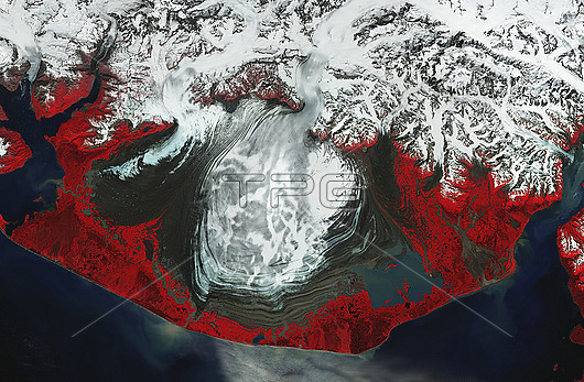
Near-infrared satellite image of the central lobe of the Malaspina Glacier, Alaska, USA, as it heads to the sea. Vegetation is red and ice and snow are white. The wavy lines are moraines, which are rock, soil and other debris deposited by the glacier. Malaspina glacier covers an area of around 2,900 square kilometres (km), flows for around 80 km along the southern base of Mount St Elias and is around 300 metres thick. It is a piedmont glacier, that is a glacier that flows from a steeply sided valley, where the ice is constrained by mountains, onto a flat plain. This change in width as it flows creates the rounded lobe that is characteristic of piedmont glaciers. Image obtained on 4th July 2022 by the Copernicus Sentinel-2 satellite.
| px | px | dpi | = | cm | x | cm | = | MB |
Details
Creative#:
TOP28948671
Source:
達志影像
Authorization Type:
RM
Release Information:
須由TPG 完整授權
Model Release:
n/a
Property Release:
n/a
Right to Privacy:
No
Same folder images:
Restriction:
This image may not be used to state or imply ESA endorsement of any company or product
 Loading