
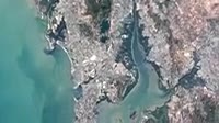
Bangkok, Thailand. Satellite image centred on Bangkok, the capital city of Thailand, showing the Bang Kachao conservation area (dark, lower centre) surrounded by an old meander of the Chao Phraya River (dark line, vertical). Bang Kachao is a lush protected area that has escaped the dense development seen elsewhere in Bangkok. The Bay of Bangkok (Bight of Bangkok, bottom) and Suvarnabhumi airport (rectangular, lower centre-right) can also be seen. Imaged by the Operational Land Imager (OLI) onboard the Landsat 8 satellite.


Details
WebID:
C01856342
Clip Type:
RF
Super High Res Size:
1920X1080
Duration:
00:00:30.000
Format:
QuickTime
Bit Rate:
25 fps
Available:
download
Comp:
200X112 (0.00 M)
Model Release:
NO
Property Release
No
 Loading