
filter
-
Brand
- By Category
- Direction
- Date Range
65Events
Pictures
Events

Editorial Charging Network
- 2024-03-25
- 10
Editorial Charging Network
- 2023-11-14
- 1
Editorial Charging Network
- 2023-11-14
- 1
Editorial Charging Network
- 2023-11-14
- 1
Editorial Charging Network
- 2023-11-01
- 1
Editorial Charging Network
- 2023-06-16
- 1

Editorial Charging Network
- 2023-04-06
- 7

Editorial Charging Network
- 2023-04-05
- 6

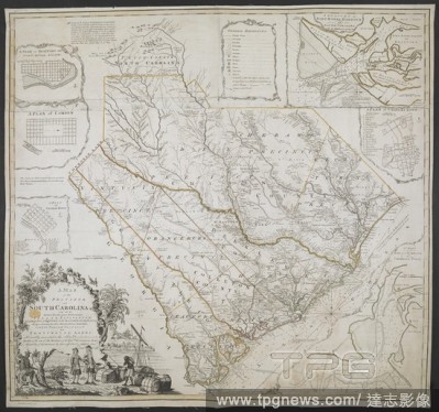
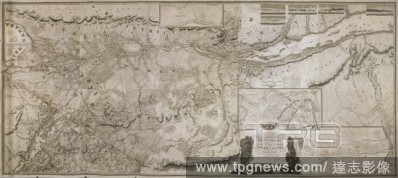
Editorial A Map of the Province of South Carolina. A MAP of the PROVINCE of SOUTH CAROLINA with all the Rivers, Creeks, Bays, Inletts, Islands, INLAND NAVIGATION, Soundings, Time of High Water on the Sea Coast, Roads, Marshes, Ferrys, Bridges, Swamps, Parishes C...
- 2022-12-24
- 1

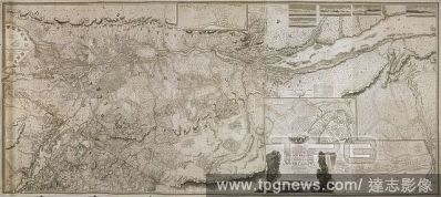
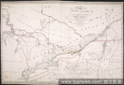
Editorial A Map of the located districts in the Province of Upper Canada, describing all the new settlements, townships . [London] : W. Faden, January 1st, 1813. Source: Maps K.Top.119.14.2.TAB. Language: English.
- 2022-12-24
- 1
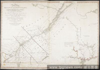
Editorial A New Map of the Province of Lower Canada. A New Map OF THE PROVINCE OF LOWER CANADA, Describing all the Seigneuries, Townships, Grants of Land, &c. Compiled from Plans deposited in the PATENT OFFICE QUEBEC... London : Published by WILLM. FADEN. Geogra...
- 2022-12-24
- 1
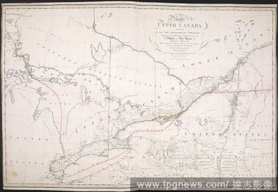
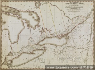
Editorial A map of the Province of Upper Canada. A Map of the Province of Upper Canada describing all the new settlements, townships, &c., with the countries adjacent, from Quebec to Lake Huron. London : W. Faden, April 12th, 1800. Source: Maps K.Top.119.13. Lan...
- 2022-12-24
- 1
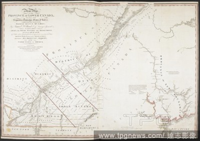
Editorial A topographical map of the Province of Lower Canada. To His Royal Highness GEORGE AUGUSTUS FREDERICK, Prince of Wales, Duke of Cornwall &c. &c. &c. and PRINCE REGENT of the United Kingdon of Great Britain & Ireland; This Topographical MAP of the Provin...
- 2022-12-24
- 1

Editorial A map of the most inhabited part of New England. An inset map (upper left) shows "A PLAN of the TOWN of BOSTON". A MAP of the most INHABITED part of NEW ENGLAND containing the PROVINCES of MASSACHUSETTS BAY and NEW HAMPSHIRE, with the COLONIES of CONEC...
- 2022-12-24
- 1
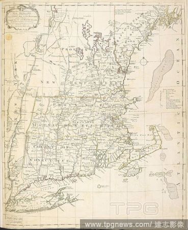
Editorial A map of New England. A Map of the most INHABITED parts of NEW ENGLAND, containing the Provinces of MASSACHUSETS BAY and NEW HAMPSHIRE, with the Colonies of CONECTICUT AND RHODE ISLAND, divided into Counties and Townships: The whole composed from Actua...
- 2022-12-24
- 1
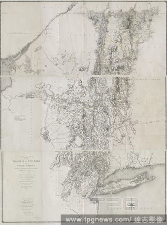
Editorial A chorographical map of the province of New-York in North America, divided into counties, manors, patents and townships : exhibiting likewise all the private grants of land made and located in that Province, cartographic, Maps, 1779, Sauthier, Claude J...
- 2022-12-24
- 1
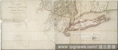
Editorial A chorographical map of the province of New-York in North America, divided into counties, manors, patents and townships : exhibiting likewise all the private grants of land made and located in that Province, cartographic, Maps, 1779, Faden, William (17...
- 2022-12-24
- 1

Editorial Celebration post local election in Majia Township, Taiwan - 26 Nov 2022
- 2022-11-27
- 2

Editorial Election day in Rinari in Majia Township, Taiwan - 26 Nov 2022
- 2022-11-27
- 2

Editorial Polling station at Rinari in Majia Township, Taiwan - 26 Nov 2022
- 2022-11-27
- 4

Editorial Votes counting after elections concluded at Rinari in Majia Township, Taiwan - 26 Nov 2022
- 2022-11-27
- 27
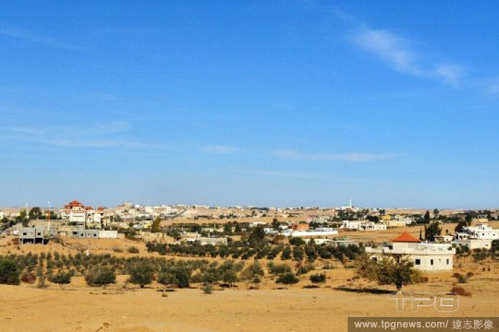
Editorial Beersheba - Israel
- 2022-10-24
- 2

Editorial Giant Geothermal Lagoon Resort To Be Built In Canada
- 2022-09-26
- 7

Editorial LG Manoj Sinha Inauguration Kashmir's First-Ever Multiplex In Srinagar After 3 Decades, Jammu And Kashmir, India - 20 Sep 2022
- 2022-09-21
- 13

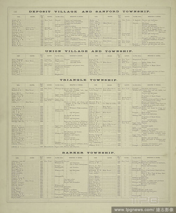
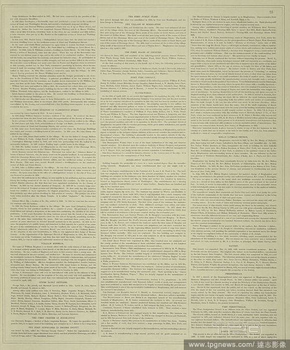
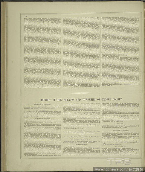
Editorial History of the Villages and Townships of Broome County. cont., still image, Atlases, 1876.
- 2022-04-25
- 1

Editorial History of Broome County, New York cont.; History of the villages and townships of Broone County.24, still image, Atlases, 1876.
- 2022-04-25
- 1
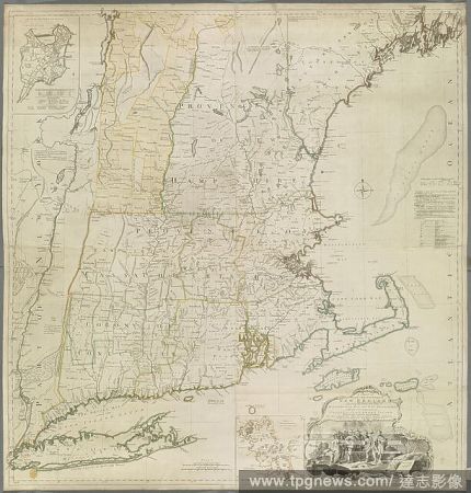
Editorial A map of the most inhabited part of New England. An inset map (upper left) shows "A PLAN of the TOWN of BOSTON". A MAP of the most INHABITED part of NEW ENGLAND containing the PROVINCES of MASSACHUSETTS BAY and NEW HAMPSHIRE, with the COLONIES of CONEC...
- 2022-01-18
- 1

Editorial A map of New England. A Map of the most INHABITED parts of NEW ENGLAND, containing the Provinces of MASSACHUSETS BAY and NEW HAMPSHIRE, with the Colonies of CONECTICUT AND RHODE ISLAND, divided into Counties and Townships: The whole composed from Actua...
- 2022-01-18
- 1
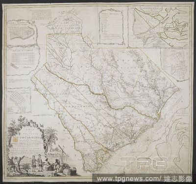
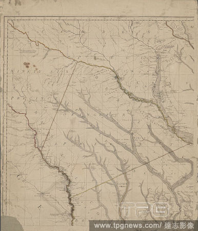
Editorial A Map of the Province of South Carolina. A MAP of the PROVINCE of SOUTH CAROLINA with all the Rivers, Creeks, Bays, Inletts, Islands, INLAND NAVIGATION, Soundings, Time of High Water on the Sea Coast, Roads, Marshes, Ferrys, Bridges, Swamps, Parishes C...
- 2022-01-18
- 1

Editorial A Map of the Province of South Carolina. A MAP of the PROVINCE of SOUTH CAROLINA with all the Rivers, Creeks, Bays, Inletts, Islands, INLAND NAVIGATION, Soundings, Time of High Water on the Sea Coast, Roads, Marshes, Ferrys, Bridges, Swamps, Parishes C...
- 2021-10-13
- 1

Editorial A Map of the Province of South Carolina. A MAP of the PROVINCE of SOUTH CAROLINA with all the Rivers, Creeks, Bays, Inletts, Islands, INLAND NAVIGATION, Soundings, Time of High Water on the Sea Coast, Roads, Marshes, Ferrys, Bridges, Swamps, Parishes C...
- 2021-10-13
- 3

Editorial Beersheba - Israel
- 2021-09-21
- 1

Editorial Beersheba - Israel
- 2021-09-21
- 2

Editorial Beersheba - Israel
- 2021-06-25
- 1

Editorial Beersheba - Israel
- 2021-06-24
- 2
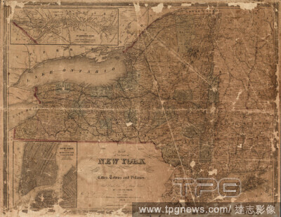
Editorial Map of the state of New York showing the location of boundaries of counties & townships, cities, towns and villages, the courses of rail roads, canals & stage roads, cartographic, Maps, 1858, Smith, J. Calvin (John Calvin), Sherman & Smith.
- 2021-04-07
- 1
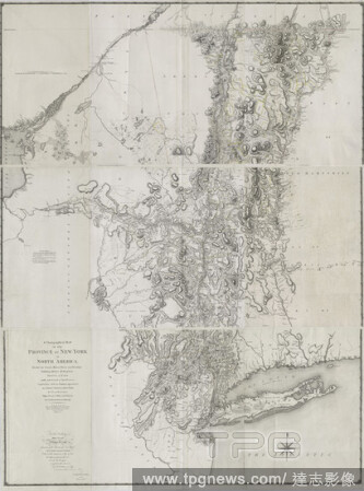
Editorial A chorographical map of the province of New-York in North America, divided into counties, manors, patents and townships : exhibiting likewise all the private grants of land made and located in that Province, cartographic, Maps, 1779, Sauthier, Claude J...
- 2021-04-07
- 1
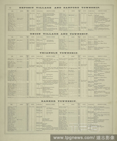
Editorial Business Directories of the Villages and Townships of Broome County, giving names, locations, and explicit directions of business of our patrons.cont., still image, Atlases, 1876.
- 2021-04-07
- 1

Editorial A chorographical map of the province of New-York in North America, divided into counties, manors, patents and townships : exhibiting likewise all the private grants of land made and located in that Province, cartographic, Maps, 1779, Faden, William (17...
- 2021-04-07
- 1
Editorial A map of South Carolina and a part of Georgia, containing the whole sea-coast : all the islands, inlets, rivers, creeks, parishes, townships, boroughs, roads, and bridges , cartographic, Maps, 1780-06-01, Sackville, George Germain, Viscount, 1716-1785,...
- 2021-04-07
- 1

Editorial Military announces martial law in Yangon, Myanmar - 16 Mar 2021
- 2021-03-17
- 9

Editorial History of the Villages and Townships of Broome County. cont., still image, Atlases, 1876.
- 2021-02-22
- 2

Editorial History of Broome County, New York cont.; History of the villages and townships of Broone County.24, still image, Atlases, 1876.
- 2021-02-22
- 2

Editorial A mapp of ye improved part of Pensilvania in America, divided into countyes, townships and lotts. Dated: c. 1687. Medium: engraving.
- 2021-02-22
- 1
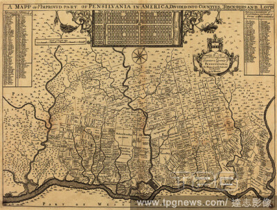
Editorial A mapp of ye improved part of Pensilvania in America, divided into countyes, townships and lotts. Dated: c. 1687. Medium: engraving.
- 2021-02-20
- 1

Editorial Semi Lockdown in Mandalay, Myanmar - 05 Dec 2020
- 2020-12-08
- 19
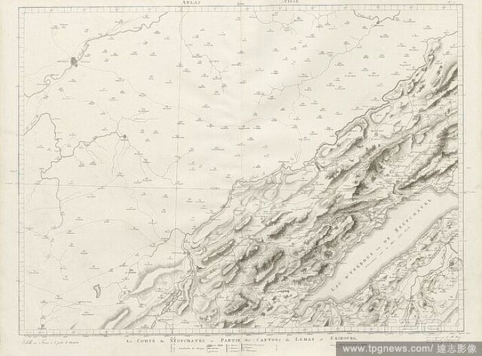
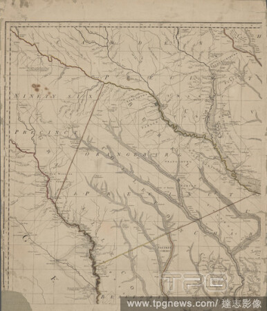
Editorial County of Neufchatel and part of the townships of L?man and Friborg, Map of Neuch?tel and parts of Friborg, Signed: J. H. Weiss, J. Scheurmann, no. 5, Weiss, Johann Heinrich (lev? et dessin?); Scheuermann, Johann Jakob (grav?), 1801, Johann Heinrich We...
- 2020-01-15
- 1
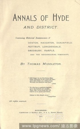
Editorial Annals of Hyde and district : containing historical reminiscences of Denton, Haughton, Dukinfield, Mottram, Longdendale, Bredbury, Marple, and the neighbouring townships : Middleton, Thomas, of Hyde.
- 2020-01-15
- 1
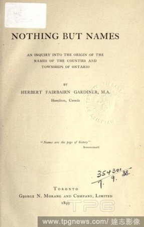
Editorial Nothing but names : an inquiry into the origin of the names of the counties and townships of Ontario : Gardiner, Herbert Fairbairn, 1849-1924.
- 2020-01-15
- 1
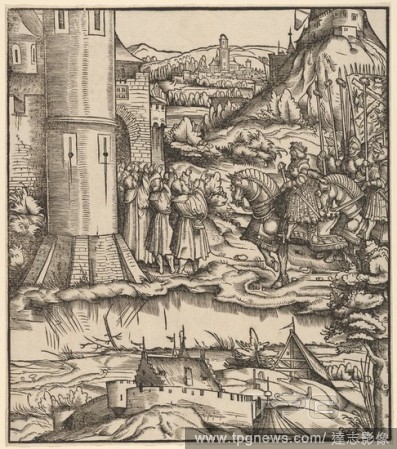
Editorial The Surrender of the Venetian Townships, from Der Weisskunig.
- 2019-02-22
- 1
Editorial A Map of the Province of South Carolina. A MAP of the PROVINCE of SOUTH CAROLINA with all the Rivers, Creeks, Bays, Inletts, Islands, INLAND NAVIGATION, Soundings, Time of High Water on the Sea Coast, Roads, Marshes, Ferrys, Bridges, Swamps, Parishes C...
- 2018-12-06
- 1
Editorial A Map of the located districts in the Province of Upper Canada, describing all the new settlements, townships . [London] : W. Faden, January 1st, 1813. Source: Maps K.Top.119.14.2.TAB. Language: English.
- 2018-12-06
- 1
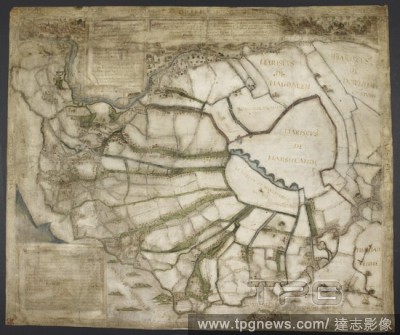
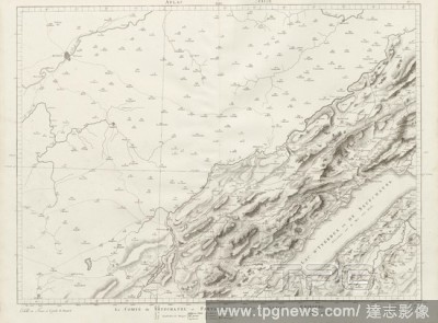
Editorial Map of seven marshland townships, near Kings Lynn, co. Norfolk; Emneth, Walsoken, Walton, Walpole, Clenchwarton, Terrington St Clement and Terrington St John. It was probably commissioned by the government to distinguish rights of summer grazing on the...
- 2018-12-06
- 1
Editorial A New Map of the Province of Lower Canada. A New Map OF THE PROVINCE OF LOWER CANADA, Describing all the Seigneuries, Townships, Grants of Land, &c. Compiled from Plans deposited in the PATENT OFFICE QUEBEC... London : Published by WILLM. FADEN. Geogra...
- 2018-12-06
- 1
Editorial A map of the Province of Upper Canada. A Map of the Province of Upper Canada describing all the new settlements, townships, &c., with the countries adjacent, from Quebec to Lake Huron. London : W. Faden, April 12th, 1800. Source: Maps K.Top.119.13. Lan...
- 2018-12-06
- 1
Editorial A topographical map of the Province of Lower Canada. To His Royal Highness GEORGE AUGUSTUS FREDERICK, Prince of Wales, Duke of Cornwall &c. &c. &c. and PRINCE REGENT of the United Kingdon of Great Britain & Ireland; This Topographical MAP of the Provin...
- 2018-12-06
- 1

Editorial A map of the most inhabited part of New England. An inset map (upper left) shows "A PLAN of the TOWN of BOSTON". A MAP of the most INHABITED part of NEW ENGLAND containing the PROVINCES of MASSACHUSETTS BAY and NEW HAMPSHIRE, with the COLONIES of CONEC...
- 2018-12-06
- 1
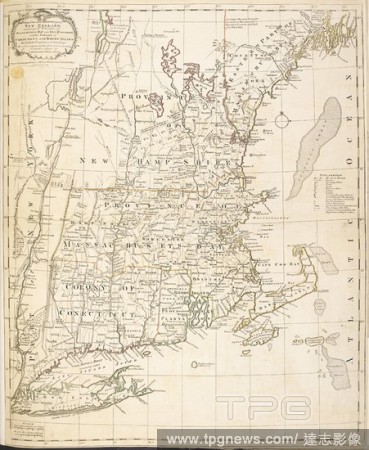
Editorial A map of New England. A Map of the most INHABITED parts of NEW ENGLAND, containing the Provinces of MASSACHUSETS BAY and NEW HAMPSHIRE, with the Colonies of CONECTICUT AND RHODE ISLAND, divided into Counties and Townships: The whole composed from Actua...
- 2018-12-06
- 1

Editorial A mapp of ye improved part of Pensilvania in America, divided into countyes, townships and lotts. Dated: c. 1687. Medium: engraving.
- 2018-11-29
- 1
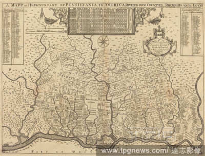
Editorial A mapp of ye improved part of Pensilvania in America, divided into countyes, townships and lotts. Dated: c. 1687. Medium: engraving.
- 2018-09-18
- 1

Editorial The Surrender of the Venetian Townships, from Der Weisskunig.
- 2018-08-09
- 1
 Loading