
filter
-
Brand
- By Category
- Direction
- Date Range
58Events
Pictures
Events

Editorial
- 2023-06-15
- 1
Editorial
- 2023-06-15
- 1
Editorial
- 2023-06-15
- 1
Editorial
- 2023-06-14
- 1
Editorial
- 2023-06-07
- 1
Editorial Four Continents, Johannes Meyer, 1655 - 1712, glass, Standing cup with medallions of two continents between scrollwork. Europe, crowned, holding scepter and shield with Habsburg coat of arms; attributes: horse, helmet, and banners (after an engraving b...
- 2022-12-24
- 1

Editorial Illustration from "Geographia", plate 36 from Woodcuts from Books of the XVI Century. Unknown Artist (German, 16th century); assembled by Max Geisberg (Swiss, 1875-1943). Date: 1525. Dimensions: 327 ? 218 mm (image/te?t); 394 ? 257 mm (sheet). Woodcut ...
- 2022-04-25
- 1
Editorial Illustration from "Geographia", plate 36 from Woodcuts from Books of the XVI Century. Unknown Artist (German, 16th century); assembled by Max Geisberg (Swiss, 1875-1943). Date: 1525. Dimensions: 327 ? 218 mm (image/te?t); 394 ? 257 mm (sheet). Woodcut ...
- 2022-04-24
- 1

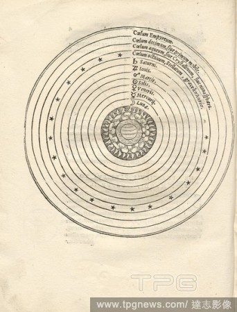
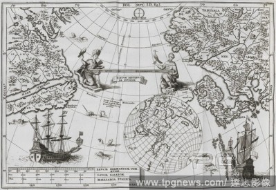
Editorial GENERALIS GEOGRAPHIA COSMICA, MATHEMATICA, NATURALIS, POLITICS (...) - 1739 - TYCHONIC SYSTEM AND COPERNICAN SYSTEM.
- 2022-01-18
- 1
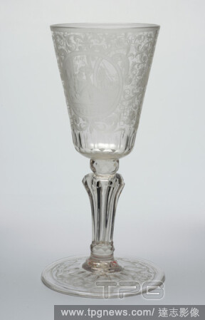
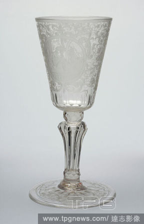
Editorial Four Continents, Johannes Meyer, 1655 - 1712, glass, Standing cup with medallions of two continents between scrollwork. Europe, crowned, holding scepter and shield with Habsburg coat of arms; attributes: horse, helmet, and banners (after an engraving b...
- 2021-02-22
- 1

Editorial Sphere model and the model sphere oblique, Illustration of the position of earth, moon and sun from the 16th century, Fig. 2, Fol. 7r, 1527, Henricus Loriti Glareanus: D.Henrici Glareani [...] De geographia liber unus. Basileae: [Faber], 1527.
- 2020-12-04
- 1
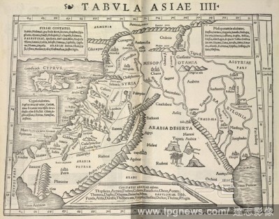
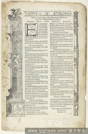
Editorial The Fourth Map of Asia showing the eastern Mediterranean and the Middle East from Cyprus to Babylon. Geographia universalis, vetus et nova; complectens Claudii Ptolem?i Alexandrini enarrationis libros VIII.; quorum primus nova translatione Pirckeimeri...
- 2020-12-04
- 1

Editorial Cats playing with boxes in a room. Fun in catland. London : Geographia, [1919?]. Source: Cup.410.c.290 page 2.
- 2020-12-04
- 1

Editorial Cats preparing for a picnic. Fun in catland. London : Geographia, [1919?]. Source: Cup.410.c.290 page 11.
- 2020-12-02
- 1

Editorial Title page on Henricus Glareanus' 'De geographia ...' 1, Title page on Henricus Glareanus' 'De geographia ...' depicting the virtues Lustitia, Prudentia, Fortidudo, Temperantia, Fides, Spes and Caritas from the 16th century;, title page, 1527, Henricus...
- 2020-01-15
- 1
Editorial Geocentric worldview, Greek world view with the sky spheres from the 16th century, Fig. 1, fol. 4v, 1527, Henricus Loriti Glareanus: D.Henrici Glareani [...] De geographia liber unus. Basileae: [Faber], 1527.
- 2020-01-15
- 1

Editorial Climate zones, Model for the classification of the climate zones from the 16th century, Fig. 4, p. 12, 1527, Henricus Loriti Glareanus: D.Henrici Glareani [...] De geographia liber unus. Basileae: [Faber], 1527.
- 2020-01-15
- 1
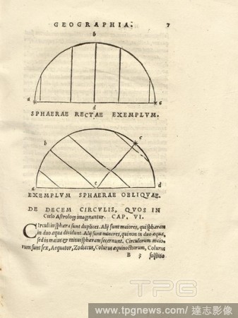
Editorial Sphere model and the model sphere oblique, Illustration of the position of earth, moon and sun from the 16th century, Fig. 2, Fol. 7r, 1527, Henricus Loriti Glareanus: D.Henrici Glareani [...] De geographia liber unus. Basileae: [Faber], 1527.
- 2020-01-15
- 1
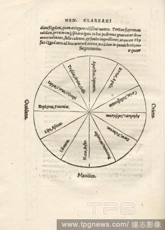
Editorial cardinal points, Illustration of the cardinal points from the 16th century, Fig. 9, p. 21, 1527, Henricus Loriti Glareanus: D.Henrici Glareani [...] De geographia liber unus. Basileae: [Faber], 1527.
- 2020-01-15
- 1
Editorial Quadrant 3, Illustration of a quadrant from the 16th century, Fig. 7, p. 18, 1527, Henricus Loriti Glareanus: D.Henrici Glareani [...] De geographia liber unus. Basileae: [Faber], 1527.
- 2020-01-15
- 1

Editorial Quadrant 2, Illustration of a quadrant from the 16th century, Fig. 6, p. 17, 1527, Henricus Loriti Glareanus: D.Henrici Glareani [...] De geographia liber unus. Basileae: [Faber], 1527.
- 2020-01-15
- 1
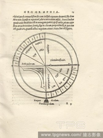
Editorial Quadrant 1, Illustration of a quadrant from the 16th century, Fig. 6, p. 17, 1527, Henricus Loriti Glareanus: D.Henrici Glareani [...] De geographia liber unus. Basileae: [Faber], 1527.
- 2020-01-15
- 1
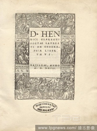
Editorial Title page on Henricus Glareanus' 'De geographia ...' 2, Title page on Henricus Glareanus' 'de geographia ...' depicting the virtues Lustitia, Prudentia, Fortidudo, Temperantia, Fides, Spes and Caritas from the 16th century;, title page, 1527, Henricus...
- 2020-01-15
- 1

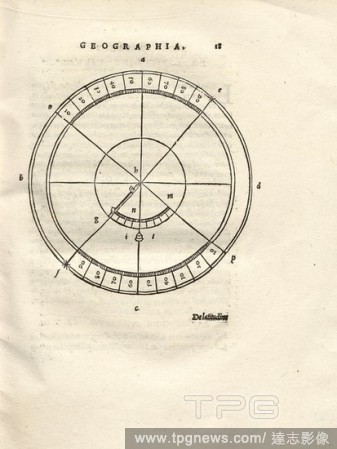
Editorial Geographic latitudes, Illustration of the geographical latitudes and the cardinal points from the 16th century, Fig. 8, according to p. 19, 1527, Henricus Loriti Glareanus: D.Henrici Glareani [...] De geographia liber unus. Basileae: [Faber], 1527.
- 2020-01-15
- 1

Editorial solar system, Illustration of the solar system and planets from the 16th century, Fig. 1, p. 4v, 1549, Henricus Loriti Glareanus: Henrici Glareani Helvetii poetae laureati de geographia liber unus ab ipso authore iam tertio recognitus. Venetiis: [Nicol...
- 2020-01-15
- 1

Editorial quarter, Illustration of the earth and its meridians from the 16th century, Fig. 5, according to p. 12, 1527, Henricus Loriti Glareanus: D.Henrici Glareani [...] De geographia liber unus. Basileae: [Faber], 1527.
- 2020-01-15
- 1
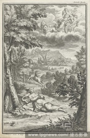
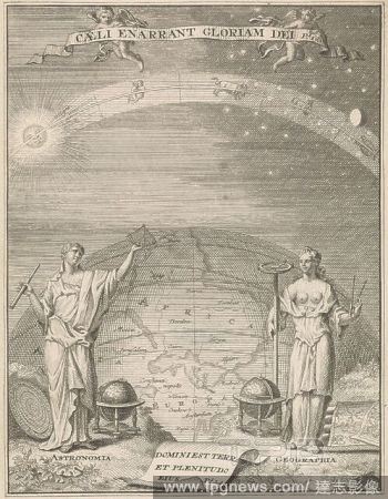
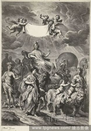
Editorial Praying woman in nature, A woman lies bare-backed on her back in the grass and has her eyes folded toward the sky. A horse gallops in the distance. In the clouds, Geographia sits on a victory cart pulled by two lions, her head is adorned with a city cr...
- 2019-12-18
- 1

Editorial Illustration from "Geographia", plate 36 from Woodcuts from Books of the XVI Century. Unknown Artist (German, 16th century); assembled by Max Geisberg (Swiss, 1875-1943). Date: 1525. Dimensions: 327 ? 218 mm (image/te?t); 394 ? 257 mm (sheet). Woodcut ...
- 2019-12-17
- 1
Editorial Illustration from "Geographia", plate 36 from Woodcuts from Books of the XVI Century. Unknown Artist (German, 16th century); assembled by Max Geisberg (Swiss, 1875-1943). Date: 1525. Dimensions: 327 ? 218 mm (image/te?t); 394 ? 257 mm (sheet). Woodcut ...
- 2019-11-18
- 1
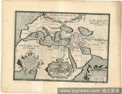
Editorial Map, Geographia sacra ex conatibus geographicis Abrahami Ortelij, Abraham Ortelius (1527-1598), Copperplate print.
- 2019-11-18
- 1

Editorial Illustration from "Geographia", plate 36 from Woodcuts from Books of the XVI Century. Unknown Artist (German, 16th century); assembled by Max Geisberg (Swiss, 1875-1943). Date: 1525. Dimensions: 327 ? 218 mm (image/te?t); 394 ? 257 mm (sheet). Woodcut ...
- 2019-03-18
- 1
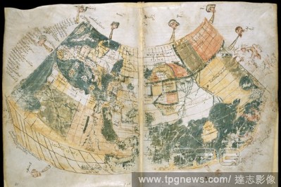
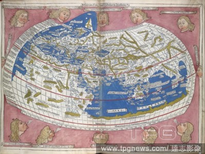
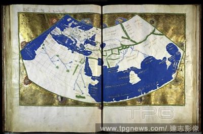
Editorial Ptolemy's World Map. Geographia. Greece [Monastery of Vatopedi, Mount Athos]; early. [Whole map] Map of the world; from the British Isles and Europe, the Mediterranean Sea and North Africa, to the Middle East, Arabia, and Asia Image taken from Geograp...
- 2018-12-06
- 1
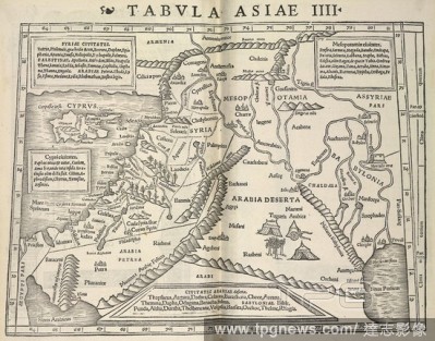
Editorial The Fourth Map of Asia showing the eastern Mediterranean and the Middle East from Cyprus to Babylon. Geographia universalis, vetus et nova; complectens Claudii Ptolem?i Alexandrini enarrationis libros VIII.; quorum primus nova translatione Pirckeimeri...
- 2018-12-06
- 1
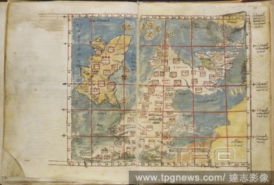
Editorial Map of the British Isles. Geographia. Greece [Monastery of Vatopedi, Mount Athos]; early. [Whole map] Map of the British Isles, with Ireland Image taken from Geographia. Originally published/produced in Greece [Monastery of Vatopedi, Mount Athos]; ea...
- 2018-12-06
- 1

Editorial Cats playing with boxes in a room. Fun in catland. London : Geographia, [1919?]. Source: Cup.410.c.290 page 2.
- 2018-12-06
- 1

Editorial Cats in various automobiles. Fun in catland. London : Geographia, [1919?]. Source: Cup.410.c.290 back cover.
- 2018-12-06
- 1

Editorial (Whole folio) Map of the British Isles, or 'Ivernia insula Britannica', a 15th century map based on one by Ptolemy, in brown ink, tinted with blue and yellow. The map is an insertion in a volume of slightly earlier date. Geographia. E. Mediterranean [G...
- 2018-12-06
- 1
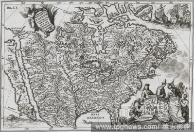
Editorial America. Atlas Novus, exhibens Orbem Terraqueum per naturae. Dilingae & Francofurti : Apud Joannem Casparum Ben. Map of America. Image taken from Atlas Novus, exhibens Orbem Terraqueum per naturae opera, historiae novae ac veteris monumenta, artisque ...
- 2018-12-06
- 1
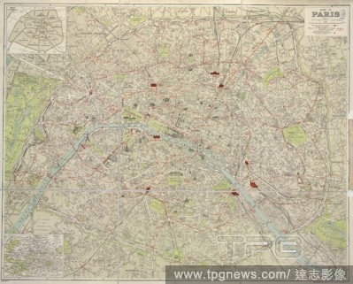
Editorial A plan of Paris. Plan de Paris. E?chelle, 1 kilome?tre[ = 73 mm.], etc. ("Geographia" Large Scale Plan of Paris. Guide de Paris. pp. 46). London : Geographia, [1925]. Source: Maps 16110.(175.). Language: French.
- 2018-12-06
- 1

Editorial Ptolemic World Map. Geographia Latin. Beatissimo Patri Paulo Secundo P. Ulm, 1482. World Map by Ptolemy. Image taken from Geographia Latin. Beatissimo Patri Paulo Secundo Pontifici. Originally published/produced in Ulm, 1482. . Source: IC.9303,.
- 2018-12-06
- 1
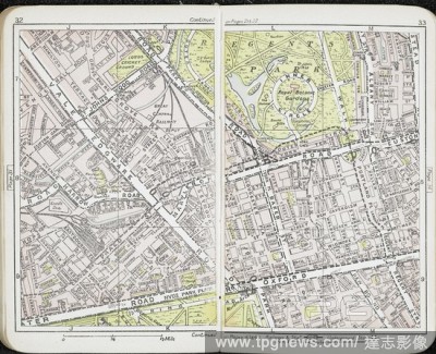
Editorial Map showing Regent's park, Euston road, Edgeware road and surrounding area. "Geographia" New Atlas and Guide to London. By A. Gross. London : "Geographia" Ltd., [1913]. Source: Maps.15.a.11 pages 32-33.
- 2018-12-06
- 1
Editorial Ptolemic World Map. Geographia Latin. Beatissimo Patri Paulo Secumdo P. Ulm, 1482. World Map by Ptolemy. Image taken from Geographia Latin. Beatissimo Patri Paulo Secumdo Pontifici Maximo. Originally published/produced in Ulm, 1482 . Source: IC.9304,.
- 2018-12-06
- 1
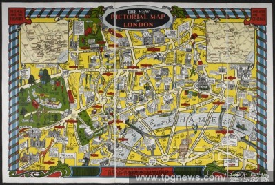
Editorial A pictorial map of London. The New Pictorial Map of London. London : "Geographia", [1931]. Source: Maps 3480.(369.). Language: English.
- 2018-12-06
- 1
Editorial America and Asia. Atlas Novus, exhibens Orbem Terraqueum per naturae. Dilingae & Francofurti : Apud Joannem Casparum Ben. Map showing part of America and Asia. Image taken from Atlas Novus, exhibens Orbem Terraqueum per naturae opera, historiae novae ...
- 2018-12-06
- 1
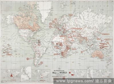
Editorial The Daily Telegraph Map of the World ... By Alexander Gross, F.R.G.S. The Daily Telegraph Map of the World ... By A. Gross, etc. (The Daily Telegraph, No. 2, Peace Conference Map of the World, etc). London : "Geographia", [1918]. 980 x 710 mm. Source: ...
- 2018-12-06
- 1
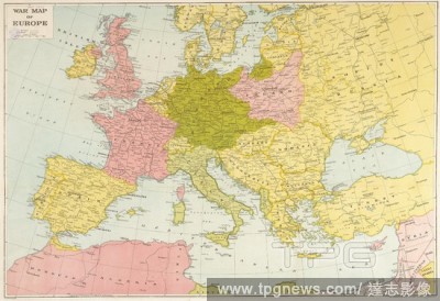
Editorial A War Map of Europe. War Map of Europe. (”Geographia” War Map No.1. Europe and the Mediterranean.) Scale of miles, 200[ = 47 mm]. London : “Geographia”, [1939]. Source: Maps 1035.(212.). Language: English.
- 2018-12-06
- 1
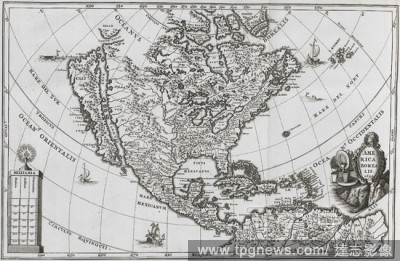
Editorial America. Atlas Novus, exhibens Orbem Terraqueum per naturae. Dilingae & Francofurti : Apud Joannem Casparum Ben. Map of North and Central America. Image taken from Atlas Novus, exhibens Orbem Terraqueum per naturae opera, historiae novae ac veteris mo...
- 2018-12-06
- 2

Editorial Nova et Accvratissima Totivs Terrarvn Orbis Tabvla.' (A New and Accurate Map of the Entire World). Two hemispheres. . [Atlas maior.] Geographia, qu? est Cosmographi? Blavian? pars prima, etc. (Geographi? Blavian? volumen secundum-undecimum.). Am...
- 2018-12-06
- 1
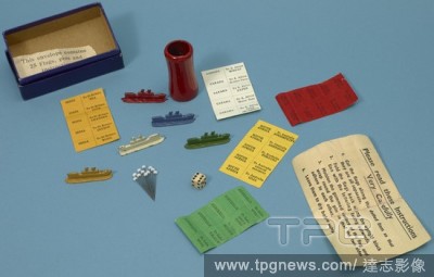
Editorial Instructions, a die, pins and tokens for the board game 'Buy British'. A new map game. Buy British. An exciting world race, and one which will teach the players Trade within the Empire. London : Geographia, [1932]. Source: Maps 162.p.6. Language: English.
- 2018-12-06
- 1

Editorial Cats preparing for a picnic. Fun in catland. London : Geographia, [1919?]. Source: Cup.410.c.290 page 11.
- 2018-12-06
- 1
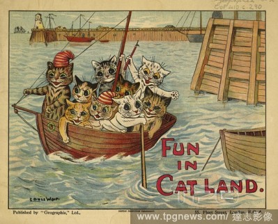
Editorial Cats in a boat. Fun in catland. London : Geographia, [1919?]. Source: Cup.410.c.290 front cover.
- 2018-12-06
- 1
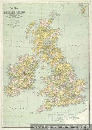
Editorial A map of the British Isles. New Map of the British Isles. Produced under the direction of A. Gross ... English miles, 50[ = 50 mm]. London : " Geographia ", [1921]. Source: Maps 1080.(70.). Language: English.
- 2018-12-06
- 1

Editorial 'Buy British' a board game showing five tokens and a die. A new map game. Buy British. An exciting world race, and one which will teach the players Trade within the Empire. London : Geographia, [1932]. Source: Maps 162.p.6. Language: English.
- 2018-12-06
- 1

Editorial 'Buy British' a board game involving trade within the British Empire. A new map game. Buy British. An exciting world race, and one which will teach the players Trade within the Empire. London : Geographia, [1932]. Source: Maps 162.p.6. Language: English.
- 2018-12-06
- 1
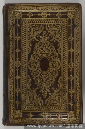
Editorial Geographia sacra. Geographia sacra, sive notitia antiqua diocesiom omnium Patriarchalium, metropoliticarum et episcopalium ... auctore Reverendis. 1703. Binding. Source: c.29.f.8 front binding.
- 2018-12-06
- 1

Editorial GENERALIS GEOGRAPHIA COSMICA, MATHEMATICA, NATURALIS, POLITICS (...) - 1739 - TYCHONIC SYSTEM AND COPERNICAN SYSTEM.
- 2018-10-11
- 1
Editorial Geographia by Ptolemy.
- 2018-07-31
- 1

Editorial GENERALIS GEOGRAPHIA COSMICA, MATHEMATICA, NATURALIS, POLITICS (...) - 1739 - TYCHONIC SYSTEM AND COPERNICAN SYSTEM.
- 2018-07-23
- 1
 Loading